You are here: Home > Network List > TA - USArray Transportable Network (new EarthScope stations) Stations List
> Station 121A Cookes Peak, Deming, NM, USA > Earthquake Result Viewer
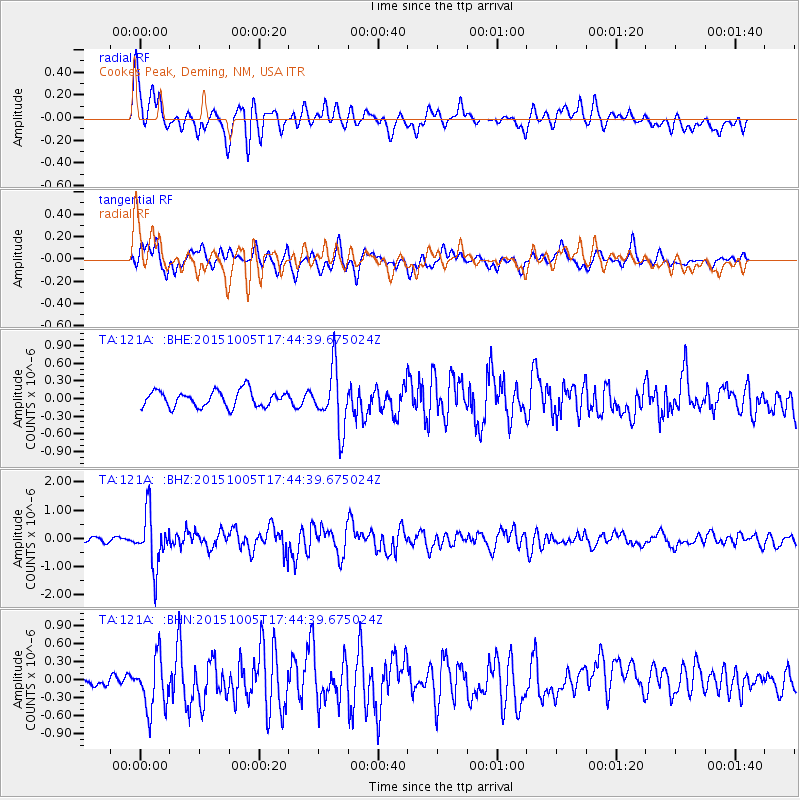
121A Cookes Peak, Deming, NM, USA - Earthquake Result Viewer
*The percent match for this event was below the threshold and hence no stack was calculated.
| Earthquake location: |
Andreanof Islands, Aleutian Is. |
| Earthquake latitude/longitude: |
51.9/-179.3 |
| Earthquake time(UTC): |
2015/10/05 (278) 17:35:55 GMT |
| Earthquake Depth: |
89 km |
| Earthquake Magnitude: |
5.7 MB |
| Earthquake Catalog/Contributor: |
NEIC PDE/NEIC ALERT |
|
| Network: |
TA USArray Transportable Network (new EarthScope stations) |
| Station: |
121A Cookes Peak, Deming, NM, USA |
| Lat/Lon: |
32.53 N/107.79 W |
| Elevation: |
1652 m |
|
| Distance: |
54.1 deg |
| Az: |
81.386 deg |
| Baz: |
313.516 deg |
| Ray Param: |
$rayparam |
*The percent match for this event was below the threshold and hence was not used in the summary stack. |
|
| Radial Match: |
70.27223 % |
| Radial Bump: |
400 |
| Transverse Match: |
67.3112 % |
| Transverse Bump: |
400 |
| SOD ConfigId: |
7422571 |
| Insert Time: |
2019-04-21 02:10:48.115 +0000 |
| GWidth: |
2.5 |
| Max Bumps: |
400 |
| Tol: |
0.001 |
|
Signal To Noise
| Channel | StoN | STA | LTA |
| TA:121A: :BHZ:20151005T17:44:39.675024Z | 6.7666187 | 9.485737E-7 | 1.401843E-7 |
| TA:121A: :BHN:20151005T17:44:39.675024Z | 3.0562468 | 4.4386113E-7 | 1.4523079E-7 |
| TA:121A: :BHE:20151005T17:44:39.675024Z | 3.785416 | 5.1063034E-7 | 1.3489412E-7 |
| Arrivals |
| Ps | |
| PpPs | |
| PsPs/PpSs | |


