You are here: Home > Network List > IU - Global Seismograph Network (GSN - IRIS/USGS) Stations List
> Station MSKU Masuku, Gabon > Earthquake Result Viewer
MSKU Masuku, Gabon - Earthquake Result Viewer
| Earthquake location: |
Southern Iran |
| Earthquake latitude/longitude: |
28.3/57.2 |
| Earthquake time(UTC): |
1999/03/04 (063) 05:38:26 GMT |
| Earthquake Depth: |
33 km |
| Earthquake Magnitude: |
6.2 MB, 6.5 MS, 6.6 MW, 6.4 MW |
| Earthquake Catalog/Contributor: |
WHDF/NEIC |
|
| Network: |
IU Global Seismograph Network (GSN - IRIS/USGS) |
| Station: |
MSKU Masuku, Gabon |
| Lat/Lon: |
1.66 S/13.61 E |
| Elevation: |
312 m |
|
| Distance: |
51.3 deg |
| Az: |
241.943 deg |
| Baz: |
51.095 deg |
| Ray Param: |
0.06741604 |
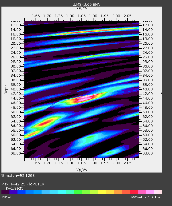
| Estimated Moho Depth: |
42.25 km |
| Estimated Crust Vp/Vs: |
1.89 |
| Assumed Crust Vp: |
6.576 km/s |
| Estimated Crust Vs: |
3.475 km/s |
| Estimated Crust Poisson's Ratio: |
0.31 |
|
| Radial Match: |
92.1293 % |
| Radial Bump: |
400 |
| Transverse Match: |
89.89917 % |
| Transverse Bump: |
400 |
| SOD ConfigId: |
4480 |
| Insert Time: |
2010-03-04 20:54:42.351 +0000 |
| GWidth: |
2.5 |
| Max Bumps: |
400 |
| Tol: |
0.001 |
|
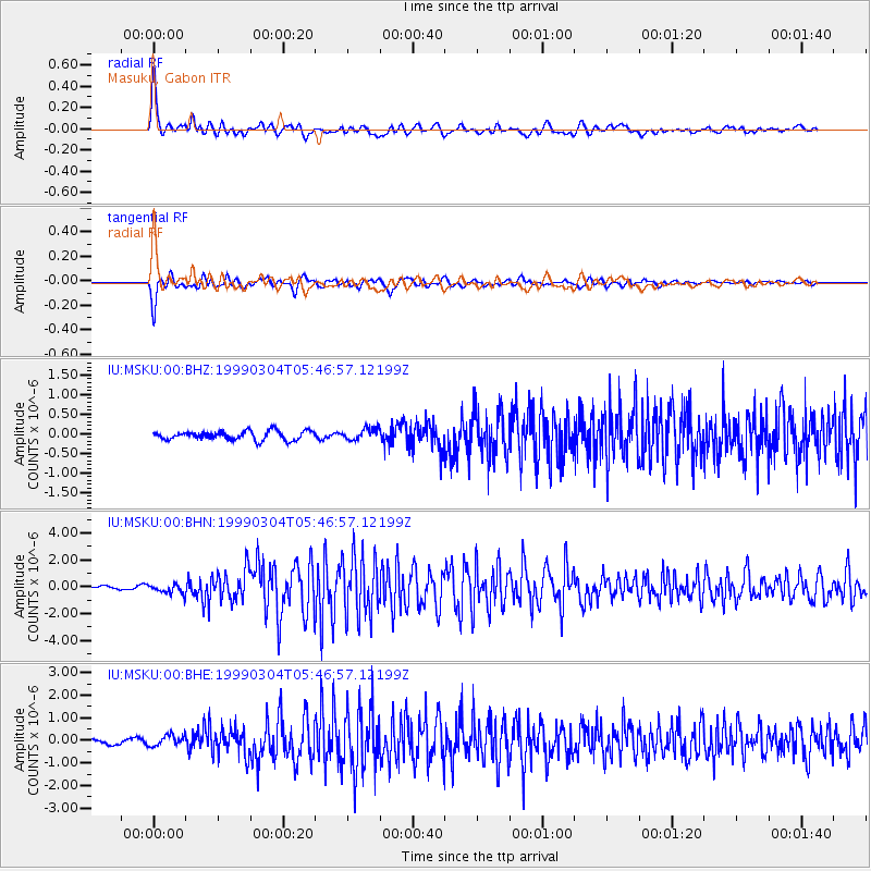
Signal To Noise
| Channel | StoN | STA | LTA |
| IU:MSKU:00:BHN:19990304T05:46:57.12199Z | 3.5180805 | 3.7306566E-7 | 1.06042386E-7 |
| IU:MSKU:00:BHE:19990304T05:46:57.12199Z | 2.3615158 | 2.492829E-7 | 1.0556054E-7 |
| IU:MSKU:00:BHZ:19990304T05:46:57.12199Z | 1.3029106 | 1.484959E-7 | 1.1397244E-7 |
| Arrivals |
| Ps | 6.1 SECOND |
| PpPs | 18 SECOND |
| PsPs/PpSs | 24 SECOND |


