You are here: Home > Network List > TA - USArray Transportable Network (new EarthScope stations) Stations List
> Station J05D Fort Rock, OR, USA > Earthquake Result Viewer
J05D Fort Rock, OR, USA - Earthquake Result Viewer

| Earthquake location: |
Andreanof Islands, Aleutian Is. |
| Earthquake latitude/longitude: |
51.9/-179.3 |
| Earthquake time(UTC): |
2015/10/05 (278) 17:35:55 GMT |
| Earthquake Depth: |
89 km |
| Earthquake Magnitude: |
5.7 MB |
| Earthquake Catalog/Contributor: |
NEIC PDE/NEIC ALERT |
|
| Network: |
TA USArray Transportable Network (new EarthScope stations) |
| Station: |
J05D Fort Rock, OR, USA |
| Lat/Lon: |
43.28 N/121.23 W |
| Elevation: |
1541 m |
|
| Distance: |
39.1 deg |
| Az: |
79.035 deg |
| Baz: |
303.599 deg |
| Ray Param: |
0.07486886 |
| Estimated Moho Depth: |
16.5 km |
| Estimated Crust Vp/Vs: |
2.03 |
| Assumed Crust Vp: |
6.597 km/s |
| Estimated Crust Vs: |
3.25 km/s |
| Estimated Crust Poisson's Ratio: |
0.34 |
|
| Radial Match: |
80.165924 % |
| Radial Bump: |
400 |
| Transverse Match: |
75.22706 % |
| Transverse Bump: |
400 |
| SOD ConfigId: |
7422571 |
| Insert Time: |
2019-04-21 02:11:06.690 +0000 |
| GWidth: |
2.5 |
| Max Bumps: |
400 |
| Tol: |
0.001 |
|
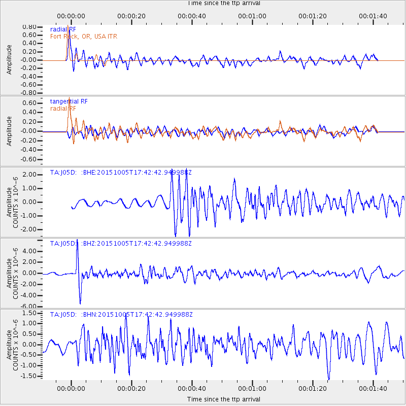
Signal To Noise
| Channel | StoN | STA | LTA |
| TA:J05D: :BHZ:20151005T17:42:42.949988Z | 15.235926 | 2.2933943E-6 | 1.5052544E-7 |
| TA:J05D: :BHN:20151005T17:42:42.949988Z | 2.1735072 | 4.9174906E-7 | 2.2624678E-7 |
| TA:J05D: :BHE:20151005T17:42:42.949988Z | 6.333126 | 1.2074843E-6 | 1.9066165E-7 |
| Arrivals |
| Ps | 2.7 SECOND |
| PpPs | 7.1 SECOND |
| PsPs/PpSs | 9.8 SECOND |


