You are here: Home > Network List > IU - Global Seismograph Network (GSN - IRIS/USGS) Stations List
> Station MSKU Masuku, Gabon > Earthquake Result Viewer
MSKU Masuku, Gabon - Earthquake Result Viewer
| Earthquake location: |
South Indian Ocean |
| Earthquake latitude/longitude: |
-39.8/41.8 |
| Earthquake time(UTC): |
2000/09/08 (252) 01:34:41 GMT |
| Earthquake Depth: |
10 km |
| Earthquake Magnitude: |
5.6 MB, 5.7 MS, 5.9 MW, 5.8 MW |
| Earthquake Catalog/Contributor: |
WHDF/NEIC |
|
| Network: |
IU Global Seismograph Network (GSN - IRIS/USGS) |
| Station: |
MSKU Masuku, Gabon |
| Lat/Lon: |
1.66 S/13.61 E |
| Elevation: |
312 m |
|
| Distance: |
45.8 deg |
| Az: |
318.885 deg |
| Baz: |
149.569 deg |
| Ray Param: |
0.071026325 |
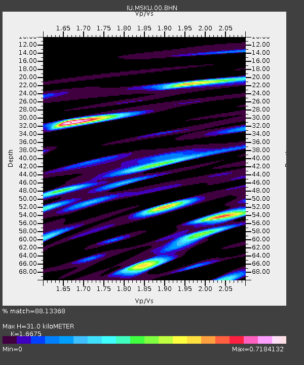
| Estimated Moho Depth: |
31.0 km |
| Estimated Crust Vp/Vs: |
1.67 |
| Assumed Crust Vp: |
6.576 km/s |
| Estimated Crust Vs: |
3.944 km/s |
| Estimated Crust Poisson's Ratio: |
0.22 |
|
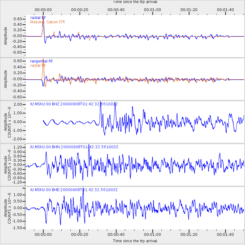
| Radial Match: |
88.13368 % |
| Radial Bump: |
400 |
| Transverse Match: |
79.39781 % |
| Transverse Bump: |
400 |
| SOD ConfigId: |
3753 |
| Insert Time: |
2010-03-04 20:54:43.948 +0000 |
| GWidth: |
2.5 |
| Max Bumps: |
400 |
| Tol: |
0.001 |
|
Signal To Noise
| Channel | StoN | STA | LTA |
| IU:MSKU:00:BHN:20000908T01:42:32.561003Z | 5.304655 | 4.3067016E-7 | 8.118721E-8 |
| IU:MSKU:00:BHE:20000908T01:42:32.561003Z | 6.6766024 | 4.6565566E-7 | 6.974441E-8 |
| IU:MSKU:00:BHZ:20000908T01:42:32.561003Z | 6.004072 | 9.0973515E-7 | 1.5151969E-7 |
| Arrivals |
| Ps | 3.4 SECOND |
| PpPs | 12 SECOND |
| PsPs/PpSs | 15 SECOND |


