You are here: Home > Network List > TA - USArray Transportable Network (new EarthScope stations) Stations List
> Station MSTX Muleshoe, TX, USA > Earthquake Result Viewer
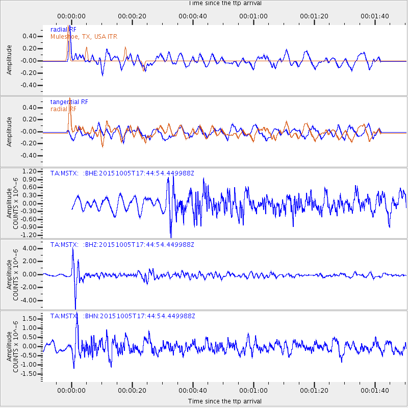
MSTX Muleshoe, TX, USA - Earthquake Result Viewer
*The percent match for this event was below the threshold and hence no stack was calculated.
| Earthquake location: |
Andreanof Islands, Aleutian Is. |
| Earthquake latitude/longitude: |
51.9/-179.3 |
| Earthquake time(UTC): |
2015/10/05 (278) 17:35:55 GMT |
| Earthquake Depth: |
89 km |
| Earthquake Magnitude: |
5.7 MB |
| Earthquake Catalog/Contributor: |
NEIC PDE/NEIC ALERT |
|
| Network: |
TA USArray Transportable Network (new EarthScope stations) |
| Station: |
MSTX Muleshoe, TX, USA |
| Lat/Lon: |
33.97 N/102.77 W |
| Elevation: |
1167 m |
|
| Distance: |
56.2 deg |
| Az: |
76.596 deg |
| Baz: |
313.515 deg |
| Ray Param: |
$rayparam |
*The percent match for this event was below the threshold and hence was not used in the summary stack. |
|
| Radial Match: |
62.756718 % |
| Radial Bump: |
399 |
| Transverse Match: |
60.928986 % |
| Transverse Bump: |
400 |
| SOD ConfigId: |
7422571 |
| Insert Time: |
2019-04-21 02:11:15.924 +0000 |
| GWidth: |
2.5 |
| Max Bumps: |
400 |
| Tol: |
0.001 |
|
Signal To Noise
| Channel | StoN | STA | LTA |
| TA:MSTX: :BHZ:20151005T17:44:54.449988Z | 8.515613 | 1.7605913E-6 | 2.0674865E-7 |
| TA:MSTX: :BHN:20151005T17:44:54.449988Z | 4.0964727 | 6.359442E-7 | 1.552419E-7 |
| TA:MSTX: :BHE:20151005T17:44:54.449988Z | 2.5335557 | 5.578372E-7 | 2.2017956E-7 |
| Arrivals |
| Ps | |
| PpPs | |
| PsPs/PpSs | |


