You are here: Home > Network List > IU - Global Seismograph Network (GSN - IRIS/USGS) Stations List
> Station MSKU Masuku, Gabon > Earthquake Result Viewer
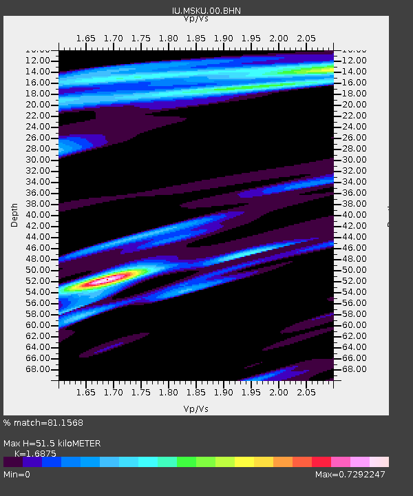
MSKU Masuku, Gabon - Earthquake Result Viewer
| Earthquake location: |
Southwest Of Africa |
| Earthquake latitude/longitude: |
-52.5/13.5 |
| Earthquake time(UTC): |
2000/04/18 (109) 00:12:05 GMT |
| Earthquake Depth: |
10 km |
| Earthquake Magnitude: |
5.4 MB, 5.3 MS, 5.8 MW, 5.7 MW |
| Earthquake Catalog/Contributor: |
WHDF/NEIC |
|
| Network: |
IU Global Seismograph Network (GSN - IRIS/USGS) |
| Station: |
MSKU Masuku, Gabon |
| Lat/Lon: |
1.66 S/13.61 E |
| Elevation: |
312 m |
|
| Distance: |
50.6 deg |
| Az: |
0.087 deg |
| Baz: |
180.054 deg |
| Ray Param: |
0.06793151 |
| Estimated Moho Depth: |
51.5 km |
| Estimated Crust Vp/Vs: |
1.69 |
| Assumed Crust Vp: |
6.576 km/s |
| Estimated Crust Vs: |
3.897 km/s |
| Estimated Crust Poisson's Ratio: |
0.23 |
|
| Radial Match: |
81.1568 % |
| Radial Bump: |
400 |
| Transverse Match: |
72.611336 % |
| Transverse Bump: |
400 |
| SOD ConfigId: |
3753 |
| Insert Time: |
2010-03-04 20:54:47.582 +0000 |
| GWidth: |
2.5 |
| Max Bumps: |
400 |
| Tol: |
0.001 |
|

Signal To Noise
| Channel | StoN | STA | LTA |
| IU:MSKU:00:BHN:20000418T00:20:33.897004Z | 3.9375968 | 3.9039176E-7 | 9.914468E-8 |
| IU:MSKU:00:BHE:20000418T00:20:33.897004Z | 1.830877 | 1.5536808E-7 | 8.485993E-8 |
| IU:MSKU:00:BHZ:20000418T00:20:33.897004Z | 5.427583 | 6.631062E-7 | 1.2217339E-7 |
| Arrivals |
| Ps | 5.7 SECOND |
| PpPs | 20 SECOND |
| PsPs/PpSs | 25 SECOND |


