You are here: Home > Network List > IU - Global Seismograph Network (GSN - IRIS/USGS) Stations List
> Station MSKU Masuku, Gabon > Earthquake Result Viewer
MSKU Masuku, Gabon - Earthquake Result Viewer
| Earthquake location: |
South Atlantic Ocean |
| Earthquake latitude/longitude: |
-53.0/-46.0 |
| Earthquake time(UTC): |
2000/08/21 (234) 09:16:25 GMT |
| Earthquake Depth: |
10 km |
| Earthquake Magnitude: |
5.8 MB, 5.9 MS, 6.1 MW, 6.1 MW |
| Earthquake Catalog/Contributor: |
WHDF/NEIC |
|
| Network: |
IU Global Seismograph Network (GSN - IRIS/USGS) |
| Station: |
MSKU Masuku, Gabon |
| Lat/Lon: |
1.66 S/13.61 E |
| Elevation: |
312 m |
|
| Distance: |
70.8 deg |
| Az: |
65.875 deg |
| Baz: |
213.475 deg |
| Ray Param: |
0.05473427 |
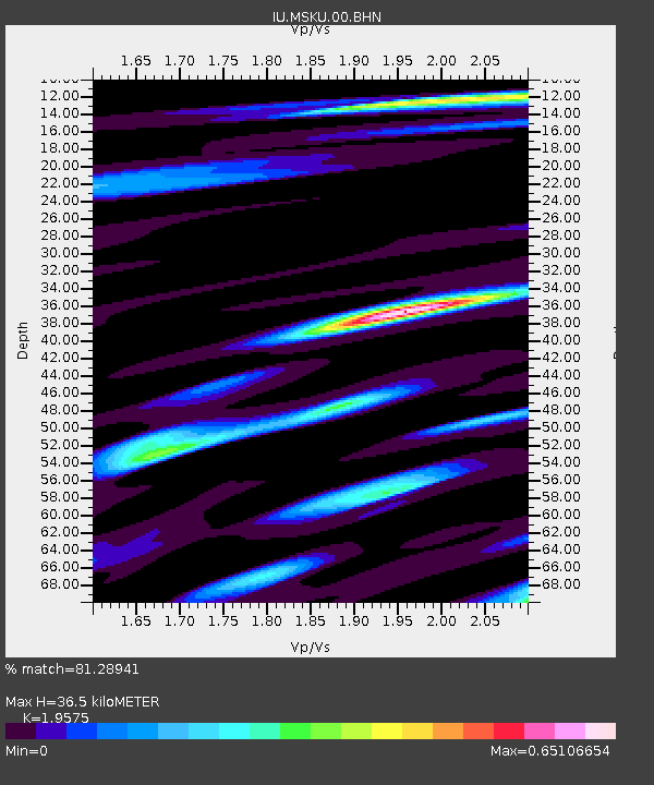
| Estimated Moho Depth: |
36.5 km |
| Estimated Crust Vp/Vs: |
1.96 |
| Assumed Crust Vp: |
6.576 km/s |
| Estimated Crust Vs: |
3.36 km/s |
| Estimated Crust Poisson's Ratio: |
0.32 |
|
| Radial Match: |
81.28941 % |
| Radial Bump: |
400 |
| Transverse Match: |
67.38624 % |
| Transverse Bump: |
400 |
| SOD ConfigId: |
3744 |
| Insert Time: |
2010-03-04 20:54:54.791 +0000 |
| GWidth: |
2.5 |
| Max Bumps: |
400 |
| Tol: |
0.001 |
|

Signal To Noise
| Channel | StoN | STA | LTA |
| IU:MSKU:00:BHN:20000821T09:27:10.861011Z | 0.70223546 | 8.823491E-8 | 1.2564863E-7 |
| IU:MSKU:00:BHE:20000821T09:27:10.861011Z | 1.2460419 | 1.1725495E-7 | 9.4101935E-8 |
| IU:MSKU:00:BHZ:20000821T09:27:10.861011Z | 1.973105 | 2.6128677E-7 | 1.3242416E-7 |
| Arrivals |
| Ps | 5.5 SECOND |
| PpPs | 16 SECOND |
| PsPs/PpSs | 21 SECOND |


