You are here: Home > Network List > IU - Global Seismograph Network (GSN - IRIS/USGS) Stations List
> Station MSKU Masuku, Gabon > Earthquake Result Viewer
MSKU Masuku, Gabon - Earthquake Result Viewer
| Earthquake location: |
Chile-Argentina Border Region |
| Earthquake latitude/longitude: |
-33.9/-70.1 |
| Earthquake time(UTC): |
2000/06/16 (168) 07:55:35 GMT |
| Earthquake Depth: |
120 km |
| Earthquake Magnitude: |
6.2 MB, 6.5 MW, 6.1 MD |
| Earthquake Catalog/Contributor: |
WHDF/NEIC |
|
| Network: |
IU Global Seismograph Network (GSN - IRIS/USGS) |
| Station: |
MSKU Masuku, Gabon |
| Lat/Lon: |
1.66 S/13.61 E |
| Elevation: |
312 m |
|
| Distance: |
83.8 deg |
| Az: |
87.868 deg |
| Baz: |
236.277 deg |
| Ray Param: |
0.045634042 |
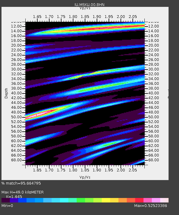
| Estimated Moho Depth: |
49.0 km |
| Estimated Crust Vp/Vs: |
1.64 |
| Assumed Crust Vp: |
6.576 km/s |
| Estimated Crust Vs: |
3.998 km/s |
| Estimated Crust Poisson's Ratio: |
0.21 |
|
| Radial Match: |
95.664795 % |
| Radial Bump: |
400 |
| Transverse Match: |
86.0005 % |
| Transverse Bump: |
400 |
| SOD ConfigId: |
3744 |
| Insert Time: |
2010-03-04 20:54:58.781 +0000 |
| GWidth: |
2.5 |
| Max Bumps: |
400 |
| Tol: |
0.001 |
|

Signal To Noise
| Channel | StoN | STA | LTA |
| IU:MSKU:00:BHN:20000616T08:07:20.436021Z | 1.4877821 | 1.7198484E-7 | 1.15598134E-7 |
| IU:MSKU:00:BHE:20000616T08:07:20.436021Z | 1.6923459 | 1.5157696E-7 | 8.956618E-8 |
| IU:MSKU:00:BHZ:20000616T08:07:20.436021Z | 4.027493 | 5.701193E-7 | 1.4155688E-7 |
| Arrivals |
| Ps | 4.9 SECOND |
| PpPs | 19 SECOND |
| PsPs/PpSs | 24 SECOND |


