You are here: Home > Network List > CI - Caltech Regional Seismic Network Stations List
> Station GSC Goldstone, Goldstone Lake, CA, USA > Earthquake Result Viewer
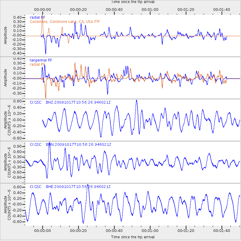
GSC Goldstone, Goldstone Lake, CA, USA - Earthquake Result Viewer
*The percent match for this event was below the threshold and hence no stack was calculated.
| Earthquake location: |
Samoa Islands Region |
| Earthquake latitude/longitude: |
-16.4/-172.0 |
| Earthquake time(UTC): |
2009/10/17 (290) 10:45:26 GMT |
| Earthquake Depth: |
10 km |
| Earthquake Magnitude: |
5.7 MB, 5.3 MS, 5.7 MW, 5.7 MW |
| Earthquake Catalog/Contributor: |
WHDF/NEIC |
|
| Network: |
CI Caltech Regional Seismic Network |
| Station: |
GSC Goldstone, Goldstone Lake, CA, USA |
| Lat/Lon: |
35.30 N/116.81 W |
| Elevation: |
1000 m |
|
| Distance: |
73.3 deg |
| Az: |
44.511 deg |
| Baz: |
235.366 deg |
| Ray Param: |
$rayparam |
*The percent match for this event was below the threshold and hence was not used in the summary stack. |
|
| Radial Match: |
65.09489 % |
| Radial Bump: |
345 |
| Transverse Match: |
61.942764 % |
| Transverse Bump: |
333 |
| SOD ConfigId: |
2622 |
| Insert Time: |
2010-02-25 23:50:54.366 +0000 |
| GWidth: |
2.5 |
| Max Bumps: |
400 |
| Tol: |
0.001 |
|
Signal To Noise
| Channel | StoN | STA | LTA |
| CI:GSC: :BHN:20091017T10:56:26.946021Z | 2.7742286 | 5.3187483E-7 | 1.9171989E-7 |
| CI:GSC: :BHE:20091017T10:56:26.946021Z | 0.9045299 | 2.1155611E-7 | 2.3388513E-7 |
| CI:GSC: :BHZ:20091017T10:56:26.946021Z | 1.4172492 | 2.8431043E-7 | 2.0060723E-7 |
| Arrivals |
| Ps | |
| PpPs | |
| PsPs/PpSs | |


