MSKU Masuku, Gabon - Earthquake Result Viewer
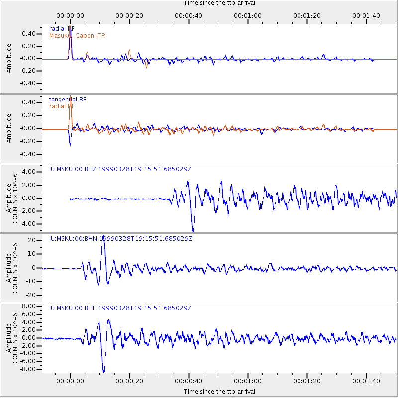
Earthquake location: Western Xizang-India Border Reg.
Earthquake latitude/longitude: 30.5/79.4
Earthquake time(UTC): 1999/03/28 (087) 19:05:11 GMT
Earthquake Depth: 15 km
Earthquake Magnitude: 6.4 MB, 6.6 MS, 6.6 MW, 6.5 ME
Earthquake Catalog/Contributor: WHDF/NEIC
Network: IU Global Seismograph Network (GSN - IRIS/USGS)
Station: MSKU Masuku, Gabon
Lat/Lon: 1.66 S/13.61 E
Elevation: 312 m
Distance: 70.2 deg
Az: 255.732 deg
Baz: 56.797 deg
Ray Param: 0.055151
Estimated Moho Depth: 45.75 km
Estimated Crust Vp/Vs: 1.82
Assumed Crust Vp: 6.576 km/s
Estimated Crust Vs: 3.608 km/s
Estimated Crust Poisson's Ratio: 0.28
Radial Match: 97.254944 %
Radial Bump: 396
Transverse Match: 95.35058 %
Transverse Bump: 400
SOD ConfigId: 4480
Insert Time: 2010-03-04 20:55:05.446 +0000
GWidth: 2.5
Max Bumps: 400
Tol: 0.001

Signal To Noise

ChannelStoNSTALTA
IU:MSKU:00:BHN:19990328T19:15:51.685029Z17.2268241.2125349E-67.038645E-8
IU:MSKU:00:BHE:19990328T19:15:51.685029Z4.49615533.8021008E-78.456338E-8
IU:MSKU:00:BHZ:19990328T19:15:51.685029Z2.99086431.9691281E-76.58381E-8
Arrivals
Ps5.9 SECOND
PpPs19 SECOND
PsPs/PpSs25 SECOND