You are here: Home > Network List > IU - Global Seismograph Network (GSN - IRIS/USGS) Stations List
> Station MSKU Masuku, Gabon > Earthquake Result Viewer
MSKU Masuku, Gabon - Earthquake Result Viewer
| Earthquake location: |
Near Coast Of Peru |
| Earthquake latitude/longitude: |
-16.7/-72.7 |
| Earthquake time(UTC): |
1999/04/03 (093) 06:17:18 GMT |
| Earthquake Depth: |
87 km |
| Earthquake Magnitude: |
6.1 MB, 6.2 MS, 6.8 MW, 6.8 MW |
| Earthquake Catalog/Contributor: |
WHDF/NEIC |
|
| Network: |
IU Global Seismograph Network (GSN - IRIS/USGS) |
| Station: |
MSKU Masuku, Gabon |
| Lat/Lon: |
1.66 S/13.61 E |
| Elevation: |
312 m |
|
| Distance: |
86.0 deg |
| Az: |
90.517 deg |
| Baz: |
253.517 deg |
| Ray Param: |
0.04421566 |
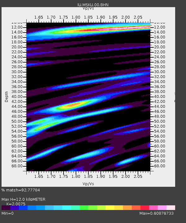
| Estimated Moho Depth: |
12.0 km |
| Estimated Crust Vp/Vs: |
2.01 |
| Assumed Crust Vp: |
6.576 km/s |
| Estimated Crust Vs: |
3.276 km/s |
| Estimated Crust Poisson's Ratio: |
0.33 |
|
| Radial Match: |
92.77784 % |
| Radial Bump: |
398 |
| Transverse Match: |
85.97215 % |
| Transverse Bump: |
400 |
| SOD ConfigId: |
4480 |
| Insert Time: |
2010-03-04 20:55:07.920 +0000 |
| GWidth: |
2.5 |
| Max Bumps: |
400 |
| Tol: |
0.001 |
|
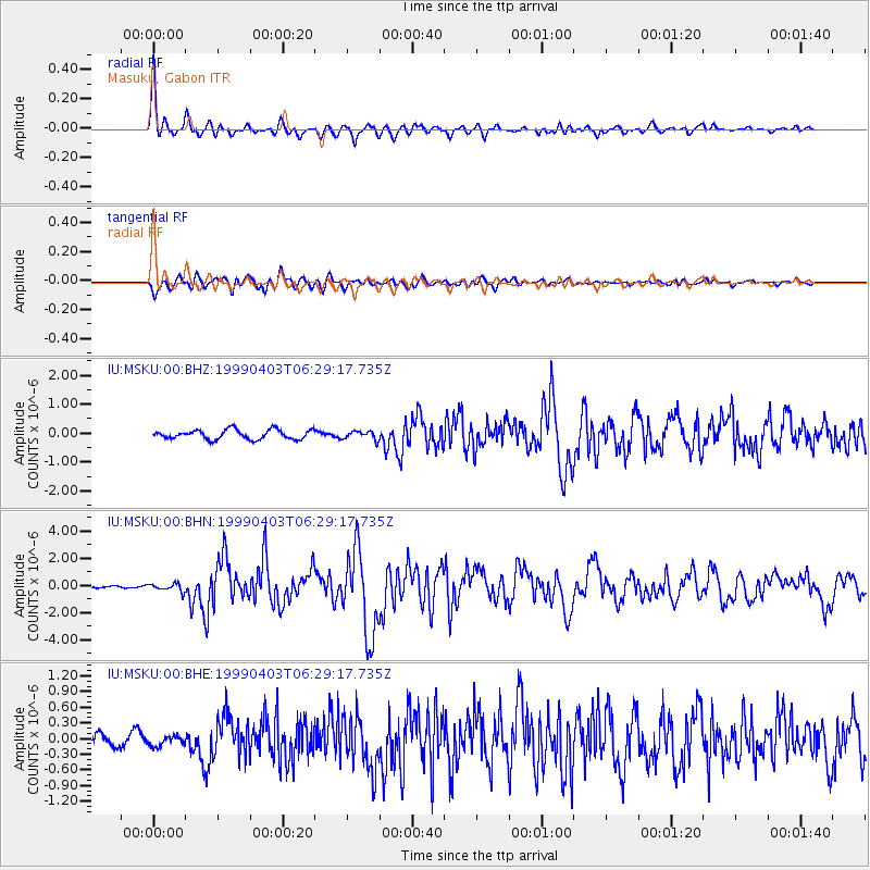
Signal To Noise
| Channel | StoN | STA | LTA |
| IU:MSKU:00:BHN:19990403T06:29:17.735Z | 2.3311245 | 2.8801702E-7 | 1.2355282E-7 |
| IU:MSKU:00:BHE:19990403T06:29:17.735Z | 0.598934 | 9.4508245E-8 | 1.5779409E-7 |
| IU:MSKU:00:BHZ:19990403T06:29:17.735Z | 0.8922809 | 1.4405008E-7 | 1.614403E-7 |
| Arrivals |
| Ps | 1.9 SECOND |
| PpPs | 5.4 SECOND |
| PsPs/PpSs | 7.2 SECOND |


