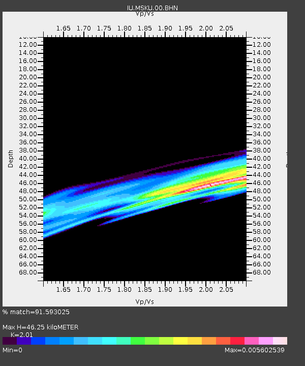
MSKU Masuku, Gabon - Earthquake Result Viewer
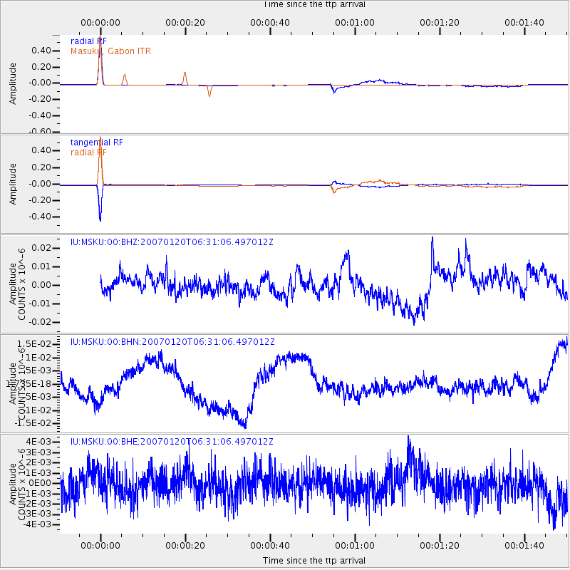
Earthquake location: South Sandwich Islands Region
Earthquake latitude/longitude: -55.4/-29.5
Earthquake time(UTC): 2007/01/20 (020) 06:21:04 GMT
Earthquake Depth: 10 km
Earthquake Magnitude: 5.7 MB, 6.2 MS, 6.2 MW, 6.1 MW
Earthquake Catalog/Contributor: WHDF/NEIC
Network: IU Global Seismograph Network (GSN - IRIS/USGS)
Station: MSKU Masuku, Gabon
Lat/Lon: 1.66 S/13.61 E
Elevation: 312 m
Distance: 63.9 deg
Az: 49.549 deg
Baz: 205.724 deg
Ray Param: 0.05925223
Estimated Moho Depth: 46.25 km
Estimated Crust Vp/Vs: 2.01
Assumed Crust Vp: 6.576 km/s
Estimated Crust Vs: 3.272 km/s
Estimated Crust Poisson's Ratio: 0.34
Radial Match: 91.593025 %
Radial Bump: 400
Transverse Match: 94.529366 %
Transverse Bump: 241
SOD ConfigId: 2564
Insert Time: 2010-03-04 20:55:12.561 +0000
GWidth: 2.5
Max Bumps: 400
Tol: 0.001

Signal To Noise

ChannelStoNSTALTA
IU:MSKU:00:BHN:20070120T06:31:06.497012Z0.443976138.159774E-91.8378858E-8
IU:MSKU:00:BHE:20070120T06:31:06.497012Z1.10464781.3245721E-91.1990899E-9
IU:MSKU:00:BHZ:20070120T06:31:06.497012Z1.10957884.4631676E-94.0223975E-9
Arrivals
Ps7.4 SECOND
PpPs20 SECOND
PsPs/PpSs28 SECOND