You are here: Home > Network List > IU - Global Seismograph Network (GSN - IRIS/USGS) Stations List
> Station MSKU Masuku, Gabon > Earthquake Result Viewer
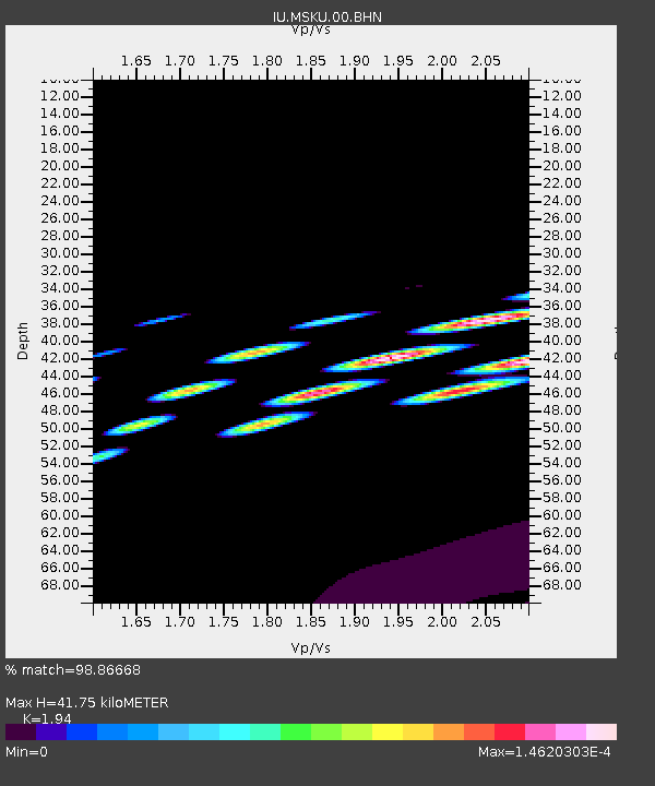
MSKU Masuku, Gabon - Earthquake Result Viewer
| Earthquake location: |
Drake Passage |
| Earthquake latitude/longitude: |
-57.9/-64.5 |
| Earthquake time(UTC): |
2007/01/17 (017) 18:34:14 GMT |
| Earthquake Depth: |
6.0 km |
| Earthquake Magnitude: |
5.6 MB, 5.1 MS, 5.6 MW, 5.6 MW |
| Earthquake Catalog/Contributor: |
WHDF/NEIC |
|
| Network: |
IU Global Seismograph Network (GSN - IRIS/USGS) |
| Station: |
MSKU Masuku, Gabon |
| Lat/Lon: |
1.66 S/13.61 E |
| Elevation: |
312 m |
|
| Distance: |
82.3 deg |
| Az: |
80.802 deg |
| Baz: |
211.813 deg |
| Ray Param: |
0.046987925 |
| Estimated Moho Depth: |
41.75 km |
| Estimated Crust Vp/Vs: |
1.94 |
| Assumed Crust Vp: |
6.576 km/s |
| Estimated Crust Vs: |
3.39 km/s |
| Estimated Crust Poisson's Ratio: |
0.32 |
|
| Radial Match: |
98.86668 % |
| Radial Bump: |
56 |
| Transverse Match: |
98.69929 % |
| Transverse Bump: |
44 |
| SOD ConfigId: |
2564 |
| Insert Time: |
2010-03-04 20:55:13.784 +0000 |
| GWidth: |
2.5 |
| Max Bumps: |
400 |
| Tol: |
0.001 |
|

Signal To Noise
| Channel | StoN | STA | LTA |
| IU:MSKU:00:BHN:20070117T18:46:05.84803Z | 0.8081186 | 1.538307E-9 | 1.903566E-9 |
| IU:MSKU:00:BHE:20070117T18:46:05.84803Z | 0.96872383 | 1.2203003E-9 | 1.2596989E-9 |
| IU:MSKU:00:BHZ:20070117T18:46:05.84803Z | 0.93538004 | 7.477821E-9 | 7.99442E-9 |
| Arrivals |
| Ps | 6.1 SECOND |
| PpPs | 18 SECOND |
| PsPs/PpSs | 24 SECOND |


