You are here: Home > Network List > IU - Global Seismograph Network (GSN - IRIS/USGS) Stations List
> Station MSKU Masuku, Gabon > Earthquake Result Viewer
MSKU Masuku, Gabon - Earthquake Result Viewer
| Earthquake location: |
Santiago Del Estero Prov., Arg. |
| Earthquake latitude/longitude: |
-26.0/-63.2 |
| Earthquake time(UTC): |
2006/11/13 (317) 01:26:34 GMT |
| Earthquake Depth: |
552 km |
| Earthquake Magnitude: |
6.3 MB, 6.8 MW, 6.8 MW |
| Earthquake Catalog/Contributor: |
WHDF/NEIC |
|
| Network: |
IU Global Seismograph Network (GSN - IRIS/USGS) |
| Station: |
MSKU Masuku, Gabon |
| Lat/Lon: |
1.66 S/13.61 E |
| Elevation: |
312 m |
|
| Distance: |
77.4 deg |
| Az: |
85.675 deg |
| Baz: |
243.824 deg |
| Ray Param: |
0.048601337 |
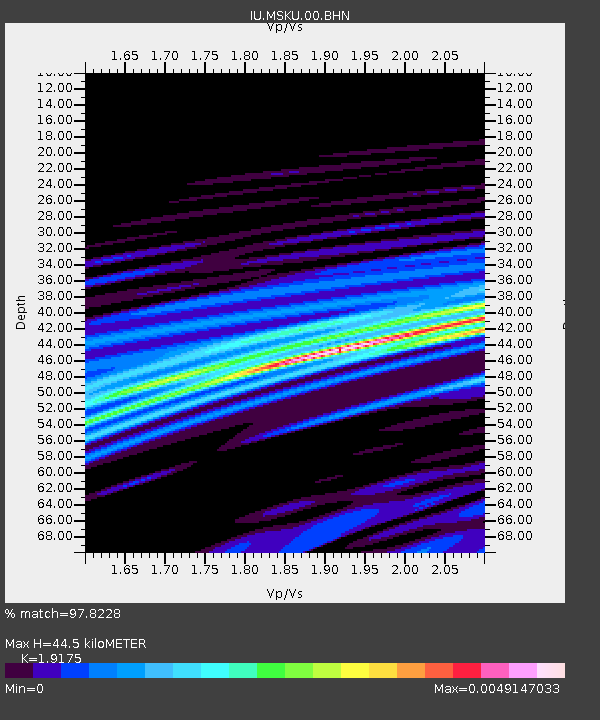
| Estimated Moho Depth: |
44.5 km |
| Estimated Crust Vp/Vs: |
1.92 |
| Assumed Crust Vp: |
6.576 km/s |
| Estimated Crust Vs: |
3.43 km/s |
| Estimated Crust Poisson's Ratio: |
0.31 |
|
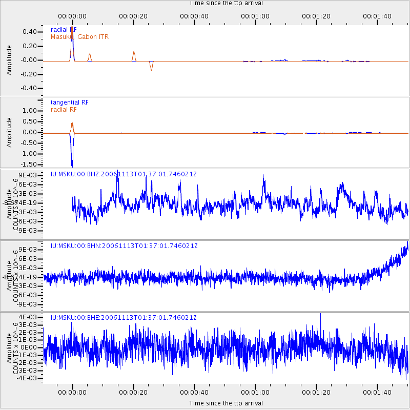
| Radial Match: |
97.8228 % |
| Radial Bump: |
70 |
| Transverse Match: |
98.648125 % |
| Transverse Bump: |
73 |
| SOD ConfigId: |
2564 |
| Insert Time: |
2010-03-04 20:55:21.081 +0000 |
| GWidth: |
2.5 |
| Max Bumps: |
400 |
| Tol: |
0.001 |
|
Signal To Noise
| Channel | StoN | STA | LTA |
| IU:MSKU:00:BHN:20061113T01:37:01.746021Z | 0.9224484 | 1.1947945E-9 | 1.2952426E-9 |
| IU:MSKU:00:BHE:20061113T01:37:01.746021Z | 0.8945917 | 1.0116531E-9 | 1.1308545E-9 |
| IU:MSKU:00:BHZ:20061113T01:37:01.746021Z | 0.75257 | 2.1678355E-9 | 2.8805767E-9 |
| Arrivals |
| Ps | 6.4 SECOND |
| PpPs | 19 SECOND |
| PsPs/PpSs | 26 SECOND |


