You are here: Home > Network List > IU - Global Seismograph Network (GSN - IRIS/USGS) Stations List
> Station SLBS Sierra la Laguna Baja California Sur, Mexico > Earthquake Result Viewer
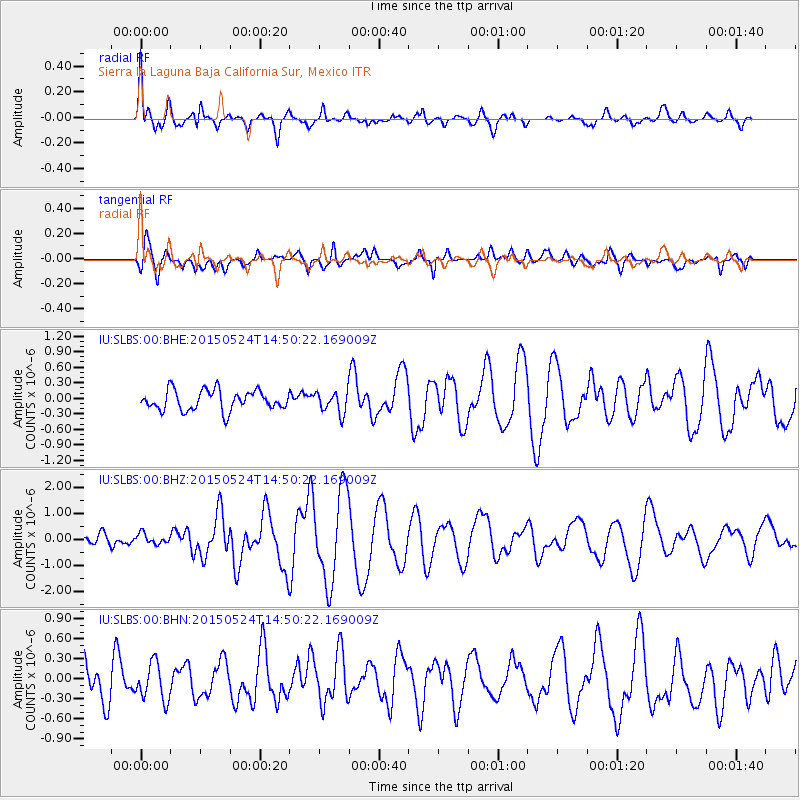
SLBS Sierra la Laguna Baja California Sur, Mexico - Earthquake Result Viewer
*The percent match for this event was below the threshold and hence no stack was calculated.
| Earthquake location: |
Tonga Islands |
| Earthquake latitude/longitude: |
-19.3/-175.9 |
| Earthquake time(UTC): |
2015/05/24 (144) 14:39:02 GMT |
| Earthquake Depth: |
35 km |
| Earthquake Magnitude: |
5.7 MB |
| Earthquake Catalog/Contributor: |
NEIC PDE/NEIC COMCAT |
|
| Network: |
IU Global Seismograph Network (GSN - IRIS/USGS) |
| Station: |
SLBS Sierra la Laguna Baja California Sur, Mexico |
| Lat/Lon: |
23.69 N/109.94 W |
| Elevation: |
825 m |
|
| Distance: |
77.3 deg |
| Az: |
59.167 deg |
| Baz: |
242.19 deg |
| Ray Param: |
$rayparam |
*The percent match for this event was below the threshold and hence was not used in the summary stack. |
|
| Radial Match: |
75.65297 % |
| Radial Bump: |
400 |
| Transverse Match: |
64.16057 % |
| Transverse Bump: |
400 |
| SOD ConfigId: |
976571 |
| Insert Time: |
2015-06-07 15:10:19.146 +0000 |
| GWidth: |
2.5 |
| Max Bumps: |
400 |
| Tol: |
0.001 |
|
Signal To Noise
| Channel | StoN | STA | LTA |
| IU:SLBS:00:BHZ:20150524T14:50:22.169009Z | 0.69343954 | 1.9949316E-7 | 2.8768645E-7 |
| IU:SLBS:00:BHN:20150524T14:50:22.169009Z | 1.1230243 | 3.0524978E-7 | 2.7181048E-7 |
| IU:SLBS:00:BHE:20150524T14:50:22.169009Z | 1.071961 | 2.0681198E-7 | 1.9292864E-7 |
| Arrivals |
| Ps | |
| PpPs | |
| PsPs/PpSs | |


