You are here: Home > Network List > IU - Global Seismograph Network (GSN - IRIS/USGS) Stations List
> Station MSKU Masuku, Gabon > Earthquake Result Viewer
MSKU Masuku, Gabon - Earthquake Result Viewer
| Earthquake location: |
Chile-Bolivia Border Region |
| Earthquake latitude/longitude: |
-21.0/-68.3 |
| Earthquake time(UTC): |
2006/10/17 (290) 04:02:37 GMT |
| Earthquake Depth: |
141 km |
| Earthquake Magnitude: |
5.5 MB, 5.9 MW |
| Earthquake Catalog/Contributor: |
WHDF/NEIC |
|
| Network: |
IU Global Seismograph Network (GSN - IRIS/USGS) |
| Station: |
MSKU Masuku, Gabon |
| Lat/Lon: |
1.66 S/13.61 E |
| Elevation: |
312 m |
|
| Distance: |
81.8 deg |
| Az: |
88.637 deg |
| Baz: |
249.106 deg |
| Ray Param: |
0.046979133 |
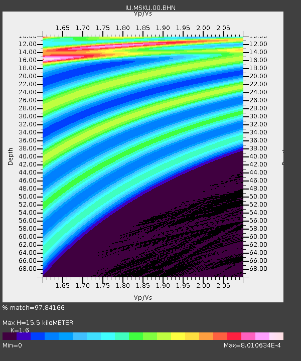
| Estimated Moho Depth: |
15.5 km |
| Estimated Crust Vp/Vs: |
1.60 |
| Assumed Crust Vp: |
6.576 km/s |
| Estimated Crust Vs: |
4.11 km/s |
| Estimated Crust Poisson's Ratio: |
0.18 |
|
| Radial Match: |
97.84166 % |
| Radial Bump: |
60 |
| Transverse Match: |
99.87411 % |
| Transverse Bump: |
23 |
| SOD ConfigId: |
2665 |
| Insert Time: |
2010-03-04 20:55:23.459 +0000 |
| GWidth: |
2.5 |
| Max Bumps: |
400 |
| Tol: |
0.001 |
|
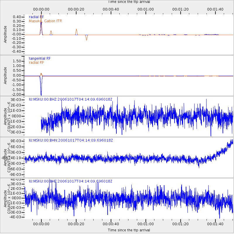
Signal To Noise
| Channel | StoN | STA | LTA |
| IU:MSKU:00:BHN:20061017T04:14:09.696018Z | 1.0306664 | 1.3661726E-9 | 1.3255237E-9 |
| IU:MSKU:00:BHE:20061017T04:14:09.696018Z | 0.96557605 | 1.0199516E-9 | 1.056314E-9 |
| IU:MSKU:00:BHZ:20061017T04:14:09.696018Z | 0.9617924 | 1.0363154E-9 | 1.0774834E-9 |
| Arrivals |
| Ps | 1.5 SECOND |
| PpPs | 5.9 SECOND |
| PsPs/PpSs | 7.4 SECOND |


