You are here: Home > Network List > IU - Global Seismograph Network (GSN - IRIS/USGS) Stations List
> Station MSKU Masuku, Gabon > Earthquake Result Viewer
MSKU Masuku, Gabon - Earthquake Result Viewer
| Earthquake location: |
South Of Africa |
| Earthquake latitude/longitude: |
-51.0/29.0 |
| Earthquake time(UTC): |
2006/10/09 (282) 18:19:33 GMT |
| Earthquake Depth: |
10 km |
| Earthquake Magnitude: |
5.4 MB, 5.3 MS, 5.7 MW, 5.7 MW |
| Earthquake Catalog/Contributor: |
WHDF/NEIC |
|
| Network: |
IU Global Seismograph Network (GSN - IRIS/USGS) |
| Station: |
MSKU Masuku, Gabon |
| Lat/Lon: |
1.66 S/13.61 E |
| Elevation: |
312 m |
|
| Distance: |
50.9 deg |
| Az: |
339.98 deg |
| Baz: |
167.51 deg |
| Ray Param: |
0.06775398 |
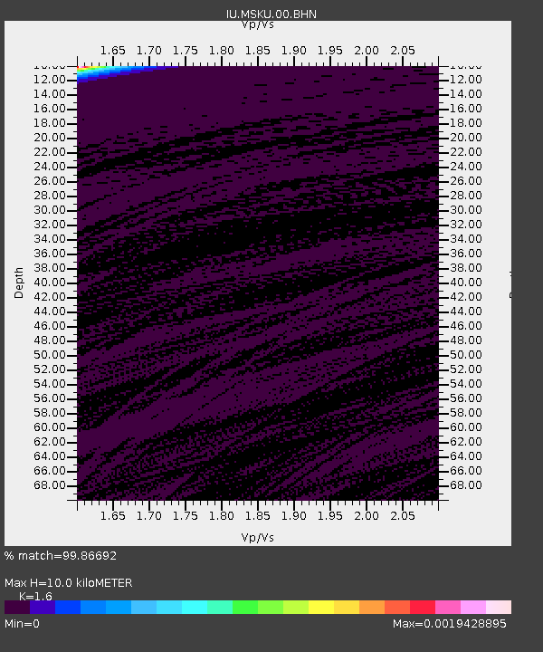
| Estimated Moho Depth: |
10.0 km |
| Estimated Crust Vp/Vs: |
1.60 |
| Assumed Crust Vp: |
6.576 km/s |
| Estimated Crust Vs: |
4.11 km/s |
| Estimated Crust Poisson's Ratio: |
0.18 |
|
| Radial Match: |
99.86692 % |
| Radial Bump: |
17 |
| Transverse Match: |
84.61782 % |
| Transverse Bump: |
174 |
| SOD ConfigId: |
2665 |
| Insert Time: |
2010-03-04 20:55:24.611 +0000 |
| GWidth: |
2.5 |
| Max Bumps: |
400 |
| Tol: |
0.001 |
|

Signal To Noise
| Channel | StoN | STA | LTA |
| IU:MSKU:00:BHN:20061009T18:28:03.895985Z | 0.9608163 | 1.0278476E-9 | 1.0697649E-9 |
| IU:MSKU:00:BHE:20061009T18:28:03.895985Z | 1.0553026 | 9.510197E-10 | 9.01182E-10 |
| IU:MSKU:00:BHZ:20061009T18:28:03.895985Z | 1.3186951 | 1.1582414E-9 | 8.783239E-10 |
| Arrivals |
| Ps | 1.0 SECOND |
| PpPs | 3.7 SECOND |
| PsPs/PpSs | 4.7 SECOND |


