You are here: Home > Network List > IU - Global Seismograph Network (GSN - IRIS/USGS) Stations List
> Station NAI Nairobi, Kenya > Earthquake Result Viewer
NAI Nairobi, Kenya - Earthquake Result Viewer
| Earthquake location: |
Java Sea |
| Earthquake latitude/longitude: |
-5.2/108.9 |
| Earthquake time(UTC): |
1995/05/13 (133) 21:00:54 GMT |
| Earthquake Depth: |
554 km |
| Earthquake Magnitude: |
5.7 MB, 5.9 UNKNOWN, 5.8 MW |
| Earthquake Catalog/Contributor: |
WHDF/NEIC |
|
| Network: |
IU Global Seismograph Network (GSN - IRIS/USGS) |
| Station: |
NAI Nairobi, Kenya |
| Lat/Lon: |
1.27 S/36.80 E |
| Elevation: |
1692 m |
|
| Distance: |
72.1 deg |
| Az: |
270.345 deg |
| Baz: |
95.036 deg |
| Ray Param: |
0.05206424 |
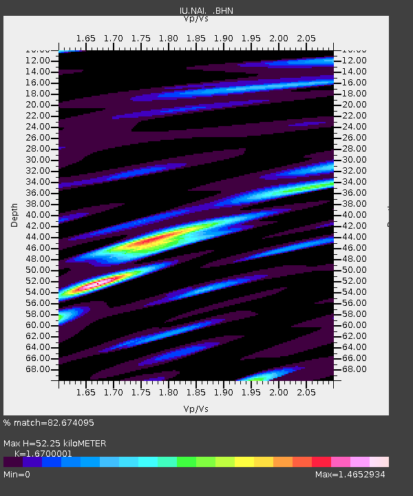
| Estimated Moho Depth: |
52.25 km |
| Estimated Crust Vp/Vs: |
1.67 |
| Assumed Crust Vp: |
6.601 km/s |
| Estimated Crust Vs: |
3.952 km/s |
| Estimated Crust Poisson's Ratio: |
0.22 |
|
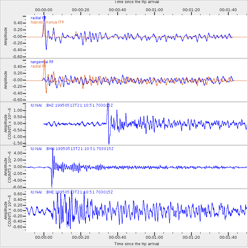
| Radial Match: |
82.674095 % |
| Radial Bump: |
400 |
| Transverse Match: |
79.5849 % |
| Transverse Bump: |
400 |
| SOD ConfigId: |
4480 |
| Insert Time: |
2010-03-04 20:55:38.067 +0000 |
| GWidth: |
2.5 |
| Max Bumps: |
400 |
| Tol: |
0.001 |
|
Signal To Noise
| Channel | StoN | STA | LTA |
| IU:NAI: :BHN:19950513T21:10:51.703015Z | 26.715912 | 1.6693814E-6 | 6.248641E-8 |
| IU:NAI: :BHE:19950513T21:10:51.703015Z | 0.9148471 | 9.4784205E-8 | 1.0360661E-7 |
| IU:NAI: :BHZ:19950513T21:10:51.703015Z | 5.950828 | 4.2266777E-7 | 7.102671E-8 |
| Arrivals |
| Ps | 5.5 SECOND |
| PpPs | 20 SECOND |
| PsPs/PpSs | 26 SECOND |


