You are here: Home > Network List > IU - Global Seismograph Network (GSN - IRIS/USGS) Stations List
> Station NAI Nairobi, Kenya > Earthquake Result Viewer
NAI Nairobi, Kenya - Earthquake Result Viewer
| Earthquake location: |
Afghanistan-Tajikistan Bord Reg. |
| Earthquake latitude/longitude: |
36.5/71.2 |
| Earthquake time(UTC): |
1995/08/17 (229) 23:14:19 GMT |
| Earthquake Depth: |
239 km |
| Earthquake Magnitude: |
5.7 UNKNOWN, 5.4 MB, 5.6 MW |
| Earthquake Catalog/Contributor: |
WHDF/NEIC |
|
| Network: |
IU Global Seismograph Network (GSN - IRIS/USGS) |
| Station: |
NAI Nairobi, Kenya |
| Lat/Lon: |
1.27 S/36.80 E |
| Elevation: |
1692 m |
|
| Distance: |
49.3 deg |
| Az: |
228.097 deg |
| Baz: |
36.879 deg |
| Ray Param: |
0.06789542 |
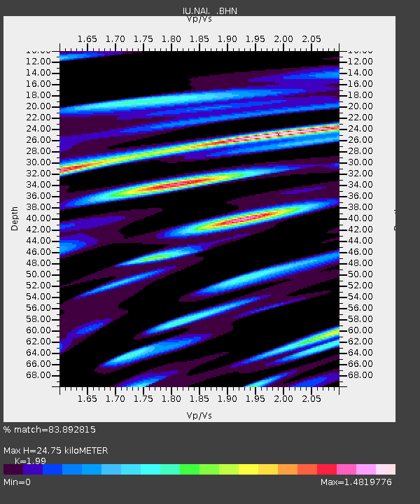
| Estimated Moho Depth: |
24.75 km |
| Estimated Crust Vp/Vs: |
1.99 |
| Assumed Crust Vp: |
6.601 km/s |
| Estimated Crust Vs: |
3.317 km/s |
| Estimated Crust Poisson's Ratio: |
0.33 |
|
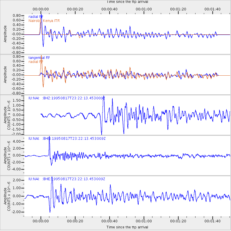
| Radial Match: |
83.892815 % |
| Radial Bump: |
400 |
| Transverse Match: |
80.21486 % |
| Transverse Bump: |
400 |
| SOD ConfigId: |
4480 |
| Insert Time: |
2010-03-04 20:55:40.917 +0000 |
| GWidth: |
2.5 |
| Max Bumps: |
400 |
| Tol: |
0.001 |
|
Signal To Noise
| Channel | StoN | STA | LTA |
| IU:NAI: :BHN:19950817T23:22:13.453009Z | 5.7484894 | 7.0068614E-7 | 1.218905E-7 |
| IU:NAI: :BHE:19950817T23:22:13.453009Z | 0.76141196 | 1.0309022E-7 | 1.3539349E-7 |
| IU:NAI: :BHZ:19950817T23:22:13.453009Z | 1.2427249 | 1.7470502E-7 | 1.4058222E-7 |
| Arrivals |
| Ps | 3.9 SECOND |
| PpPs | 11 SECOND |
| PsPs/PpSs | 15 SECOND |


