You are here: Home > Network List > TA - USArray Transportable Network (new EarthScope stations) Stations List
> Station J01E Myrtle Point, OR, USA > Earthquake Result Viewer
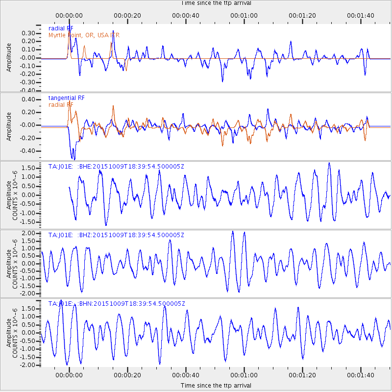
J01E Myrtle Point, OR, USA - Earthquake Result Viewer
*The percent match for this event was below the threshold and hence no stack was calculated.
| Earthquake location: |
Near Coast Of Central Chile |
| Earthquake latitude/longitude: |
-31.7/-71.7 |
| Earthquake time(UTC): |
2015/10/09 (282) 18:27:36 GMT |
| Earthquake Depth: |
35 km |
| Earthquake Magnitude: |
5.5 MWW, 5.4 MWR, 5.4 MWB |
| Earthquake Catalog/Contributor: |
NEIC PDE/NEIC COMCAT |
|
| Network: |
TA USArray Transportable Network (new EarthScope stations) |
| Station: |
J01E Myrtle Point, OR, USA |
| Lat/Lon: |
43.16 N/123.93 W |
| Elevation: |
128 m |
|
| Distance: |
88.5 deg |
| Az: |
324.668 deg |
| Baz: |
137.668 deg |
| Ray Param: |
$rayparam |
*The percent match for this event was below the threshold and hence was not used in the summary stack. |
|
| Radial Match: |
57.766644 % |
| Radial Bump: |
400 |
| Transverse Match: |
43.34504 % |
| Transverse Bump: |
400 |
| SOD ConfigId: |
7422571 |
| Insert Time: |
2019-04-21 02:20:40.814 +0000 |
| GWidth: |
2.5 |
| Max Bumps: |
400 |
| Tol: |
0.001 |
|
Signal To Noise
| Channel | StoN | STA | LTA |
| TA:J01E: :BHZ:20151009T18:39:54.500005Z | 1.4302303 | 1.1280997E-6 | 7.8875394E-7 |
| TA:J01E: :BHN:20151009T18:39:54.500005Z | 2.0858843 | 1.3878403E-6 | 6.6534864E-7 |
| TA:J01E: :BHE:20151009T18:39:54.500005Z | 0.9880248 | 6.954529E-7 | 7.0388205E-7 |
| Arrivals |
| Ps | |
| PpPs | |
| PsPs/PpSs | |


