You are here: Home > Network List > IU - Global Seismograph Network (GSN - IRIS/USGS) Stations List
> Station NAI Nairobi, Kenya > Earthquake Result Viewer
NAI Nairobi, Kenya - Earthquake Result Viewer
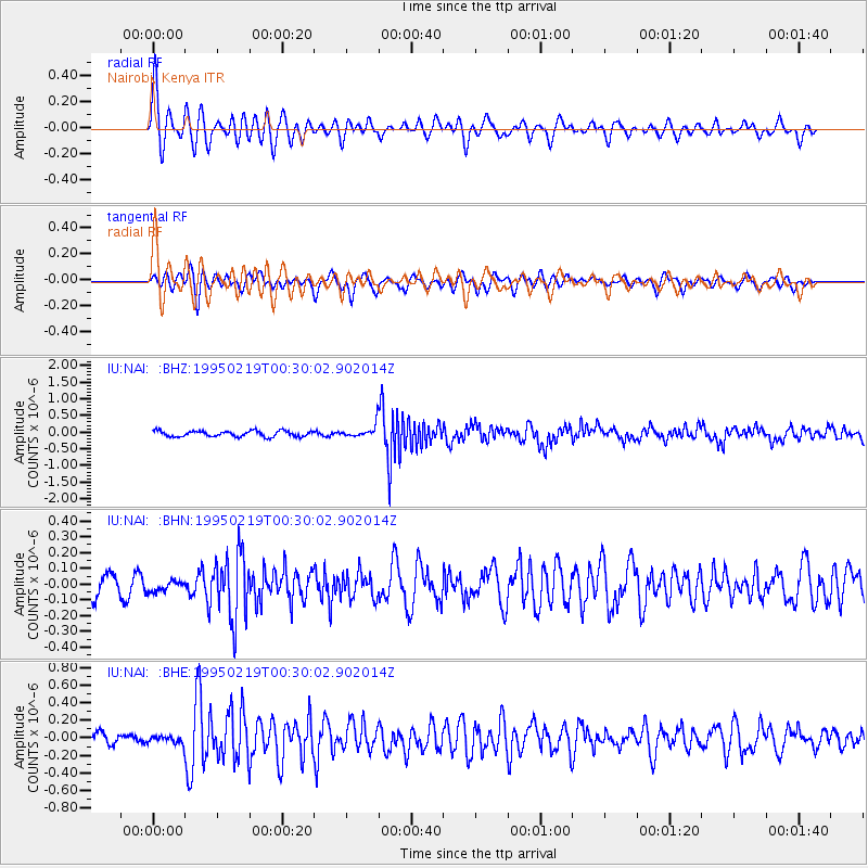
| Earthquake location: |
Mindanao, Philippines |
| Earthquake latitude/longitude: |
5.2/126.2 |
| Earthquake time(UTC): |
1995/02/19 (050) 00:17:48 GMT |
| Earthquake Depth: |
104 km |
| Earthquake Magnitude: |
5.9 MB, 6.1 UNKNOWN, 6.1 MW |
| Earthquake Catalog/Contributor: |
WHDF/NEIC |
|
| Network: |
IU Global Seismograph Network (GSN - IRIS/USGS) |
| Station: |
NAI Nairobi, Kenya |
| Lat/Lon: |
1.27 S/36.80 E |
| Elevation: |
1692 m |
|
| Distance: |
89.5 deg |
| Az: |
268.688 deg |
| Baz: |
84.817 deg |
| Ray Param: |
0.041717093 |
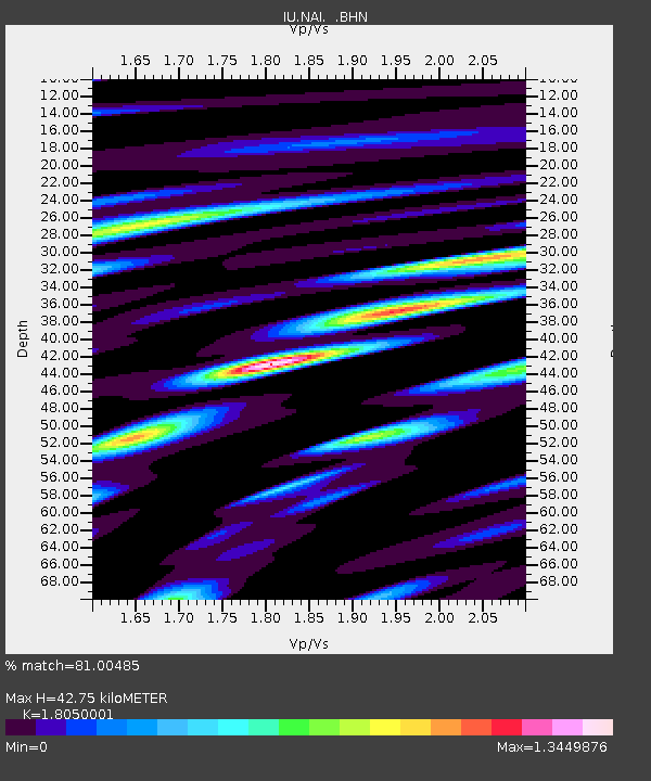
| Estimated Moho Depth: |
42.75 km |
| Estimated Crust Vp/Vs: |
1.81 |
| Assumed Crust Vp: |
6.601 km/s |
| Estimated Crust Vs: |
3.657 km/s |
| Estimated Crust Poisson's Ratio: |
0.28 |
|
| Radial Match: |
81.00485 % |
| Radial Bump: |
400 |
| Transverse Match: |
65.800285 % |
| Transverse Bump: |
400 |
| SOD ConfigId: |
6273 |
| Insert Time: |
2010-03-04 20:55:47.828 +0000 |
| GWidth: |
2.5 |
| Max Bumps: |
400 |
| Tol: |
0.001 |
|
Signal To Noise
| Channel | StoN | STA | LTA |
| IU:NAI: :BHN:19950219T00:30:02.902014Z | 0.59553456 | 3.5281662E-8 | 5.9243682E-8 |
| IU:NAI: :BHE:19950219T00:30:02.902014Z | 0.7886964 | 4.7100798E-8 | 5.97198E-8 |
| IU:NAI: :BHZ:19950219T00:30:02.902014Z | 2.2109442 | 1.8829589E-7 | 8.516537E-8 |
| Arrivals |
| Ps | 5.3 SECOND |
| PpPs | 18 SECOND |
| PsPs/PpSs | 23 SECOND |


