You are here: Home > Network List > UU - University of Utah Regional Network Stations List
> Station WPUT Wasatch Plateau, UT,USA > Earthquake Result Viewer
WPUT Wasatch Plateau, UT,USA - Earthquake Result Viewer
| Earthquake location: |
Tonga Islands |
| Earthquake latitude/longitude: |
-19.3/-175.9 |
| Earthquake time(UTC): |
2015/05/24 (144) 14:39:02 GMT |
| Earthquake Depth: |
35 km |
| Earthquake Magnitude: |
5.7 MB |
| Earthquake Catalog/Contributor: |
NEIC PDE/NEIC COMCAT |
|
| Network: |
UU University of Utah Regional Network |
| Station: |
WPUT Wasatch Plateau, UT,USA |
| Lat/Lon: |
39.00 N/111.36 W |
| Elevation: |
2618 m |
|
| Distance: |
83.7 deg |
| Az: |
45.08 deg |
| Baz: |
239.106 deg |
| Ray Param: |
0.045948066 |
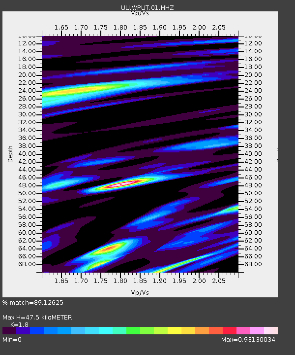
| Estimated Moho Depth: |
47.5 km |
| Estimated Crust Vp/Vs: |
1.80 |
| Assumed Crust Vp: |
6.207 km/s |
| Estimated Crust Vs: |
3.448 km/s |
| Estimated Crust Poisson's Ratio: |
0.28 |
|
| Radial Match: |
89.12625 % |
| Radial Bump: |
370 |
| Transverse Match: |
90.42502 % |
| Transverse Bump: |
390 |
| SOD ConfigId: |
976571 |
| Insert Time: |
2015-06-07 15:11:53.352 +0000 |
| GWidth: |
2.5 |
| Max Bumps: |
400 |
| Tol: |
0.001 |
|
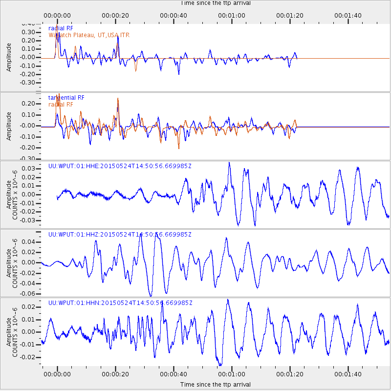
Signal To Noise
| Channel | StoN | STA | LTA |
| UU:WPUT:01:HHZ:20150524T14:50:56.669985Z | 1.3520275 | 3.495681E-9 | 2.5855103E-9 |
| UU:WPUT:01:HHN:20150524T14:50:56.669985Z | 0.90882254 | 2.6001032E-9 | 2.8609581E-9 |
| UU:WPUT:01:HHE:20150524T14:50:56.669985Z | 1.8447827 | 5.1089657E-9 | 2.7694131E-9 |
| Arrivals |
| Ps | 6.3 SECOND |
| PpPs | 21 SECOND |
| PsPs/PpSs | 27 SECOND |


