You are here: Home > Network List > IU - Global Seismograph Network (GSN - IRIS/USGS) Stations List
> Station NAI Nairobi, Kenya > Earthquake Result Viewer
NAI Nairobi, Kenya - Earthquake Result Viewer
| Earthquake location: |
Mindanao, Philippines |
| Earthquake latitude/longitude: |
6.3/126.8 |
| Earthquake time(UTC): |
1995/04/20 (110) 08:45:10 GMT |
| Earthquake Depth: |
85 km |
| Earthquake Magnitude: |
6.2 MB, 6.6 UNKNOWN, 6.5 MW |
| Earthquake Catalog/Contributor: |
WHDF/NEIC |
|
| Network: |
IU Global Seismograph Network (GSN - IRIS/USGS) |
| Station: |
NAI Nairobi, Kenya |
| Lat/Lon: |
1.27 S/36.80 E |
| Elevation: |
1692 m |
|
| Distance: |
90.2 deg |
| Az: |
268.745 deg |
| Baz: |
83.756 deg |
| Ray Param: |
0.04167709 |
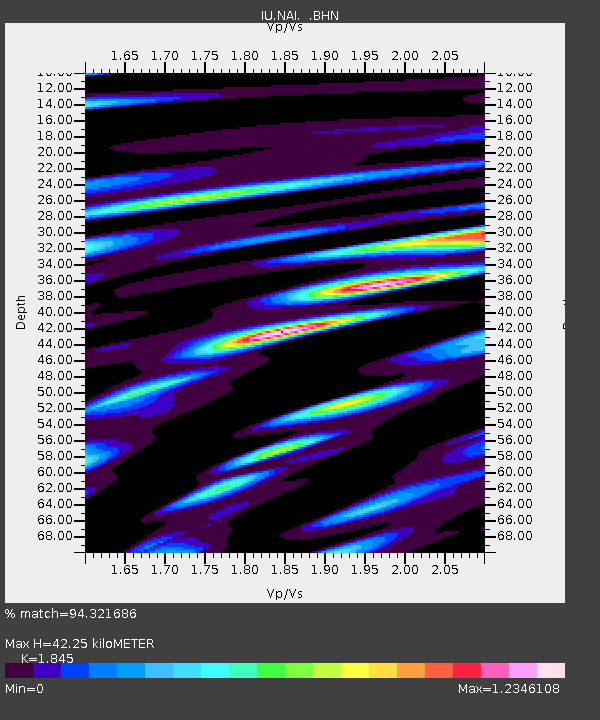
| Estimated Moho Depth: |
42.25 km |
| Estimated Crust Vp/Vs: |
1.85 |
| Assumed Crust Vp: |
6.601 km/s |
| Estimated Crust Vs: |
3.578 km/s |
| Estimated Crust Poisson's Ratio: |
0.29 |
|
| Radial Match: |
94.321686 % |
| Radial Bump: |
400 |
| Transverse Match: |
79.73921 % |
| Transverse Bump: |
400 |
| SOD ConfigId: |
6273 |
| Insert Time: |
2010-03-04 20:55:52.617 +0000 |
| GWidth: |
2.5 |
| Max Bumps: |
400 |
| Tol: |
0.001 |
|
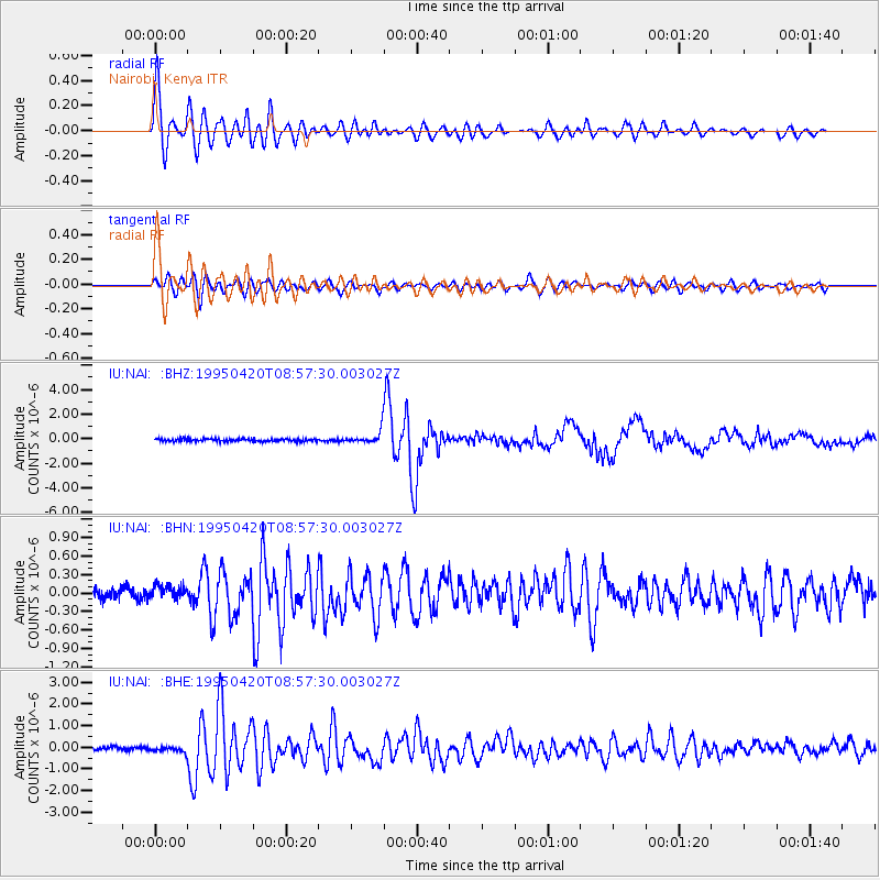
Signal To Noise
| Channel | StoN | STA | LTA |
| IU:NAI: :BHN:19950420T08:57:30.003027Z | 1.0064782 | 9.4469414E-8 | 9.386137E-8 |
| IU:NAI: :BHE:19950420T08:57:30.003027Z | 1.4171854 | 1.2720184E-7 | 8.9756675E-8 |
| IU:NAI: :BHZ:19950420T08:57:30.003027Z | 4.851861 | 5.2616303E-7 | 1.0844562E-7 |
| Arrivals |
| Ps | 5.5 SECOND |
| PpPs | 18 SECOND |
| PsPs/PpSs | 23 SECOND |


