You are here: Home > Network List > IU - Global Seismograph Network (GSN - IRIS/USGS) Stations List
> Station NAI Nairobi, Kenya > Earthquake Result Viewer
NAI Nairobi, Kenya - Earthquake Result Viewer
| Earthquake location: |
Halmahera, Indonesia |
| Earthquake latitude/longitude: |
1.9/128.5 |
| Earthquake time(UTC): |
1995/05/04 (124) 02:18:51 GMT |
| Earthquake Depth: |
55 km |
| Earthquake Magnitude: |
6.0 MB, 6.0 MS, 6.1 UNKNOWN, 6.1 MW |
| Earthquake Catalog/Contributor: |
WHDF/NEIC |
|
| Network: |
IU Global Seismograph Network (GSN - IRIS/USGS) |
| Station: |
NAI Nairobi, Kenya |
| Lat/Lon: |
1.27 S/36.80 E |
| Elevation: |
1692 m |
|
| Distance: |
91.7 deg |
| Az: |
268.789 deg |
| Baz: |
88.192 deg |
| Ray Param: |
0.041547436 |
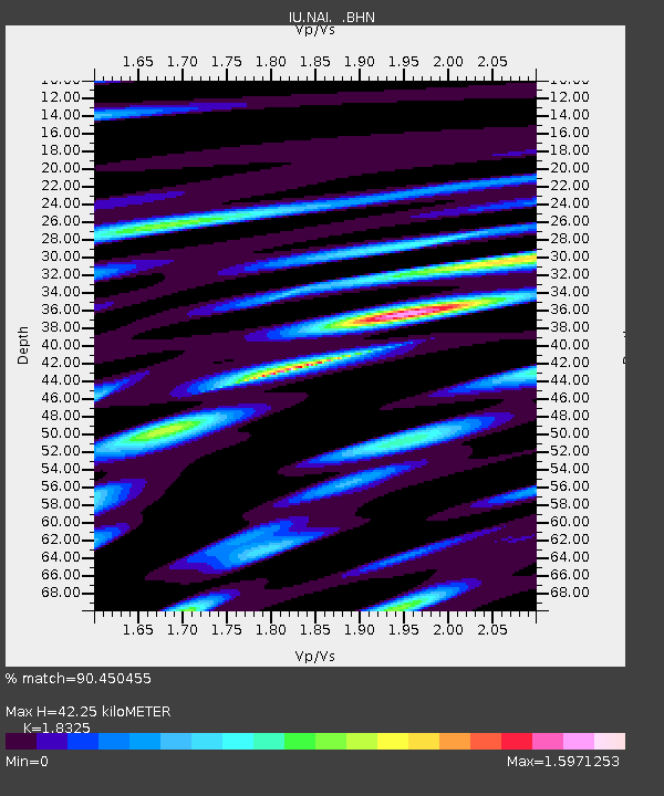
| Estimated Moho Depth: |
42.25 km |
| Estimated Crust Vp/Vs: |
1.83 |
| Assumed Crust Vp: |
6.601 km/s |
| Estimated Crust Vs: |
3.602 km/s |
| Estimated Crust Poisson's Ratio: |
0.29 |
|
| Radial Match: |
90.450455 % |
| Radial Bump: |
400 |
| Transverse Match: |
84.48459 % |
| Transverse Bump: |
400 |
| SOD ConfigId: |
6273 |
| Insert Time: |
2010-03-04 20:55:55.053 +0000 |
| GWidth: |
2.5 |
| Max Bumps: |
400 |
| Tol: |
0.001 |
|
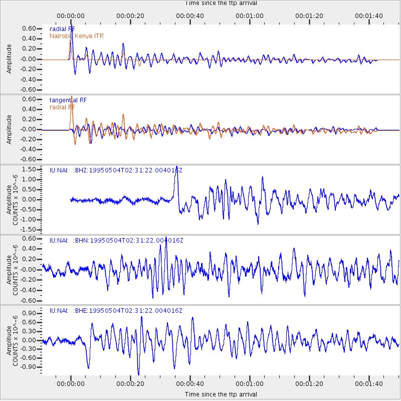
Signal To Noise
| Channel | StoN | STA | LTA |
| IU:NAI: :BHN:19950504T02:31:22.004016Z | 0.7335852 | 5.724341E-8 | 7.803239E-8 |
| IU:NAI: :BHE:19950504T02:31:22.004016Z | 0.9117439 | 8.521854E-8 | 9.346763E-8 |
| IU:NAI: :BHZ:19950504T02:31:22.004016Z | 2.4764166 | 1.9180605E-7 | 7.7453066E-8 |
| Arrivals |
| Ps | 5.4 SECOND |
| PpPs | 18 SECOND |
| PsPs/PpSs | 23 SECOND |


