You are here: Home > Network List > IU - Global Seismograph Network (GSN - IRIS/USGS) Stations List
> Station NAI Nairobi, Kenya > Earthquake Result Viewer
NAI Nairobi, Kenya - Earthquake Result Viewer
| Earthquake location: |
Samar, Philippines |
| Earthquake latitude/longitude: |
12.6/125.3 |
| Earthquake time(UTC): |
1995/05/05 (125) 03:53:47 GMT |
| Earthquake Depth: |
33 km |
| Earthquake Magnitude: |
6.2 MB, 7.0 MS, 7.1 UNKNOWN, 7.0 MW |
| Earthquake Catalog/Contributor: |
WHDF/NEIC |
|
| Network: |
IU Global Seismograph Network (GSN - IRIS/USGS) |
| Station: |
NAI Nairobi, Kenya |
| Lat/Lon: |
1.27 S/36.80 E |
| Elevation: |
1692 m |
|
| Distance: |
88.8 deg |
| Az: |
268.441 deg |
| Baz: |
77.427 deg |
| Ray Param: |
0.042258687 |
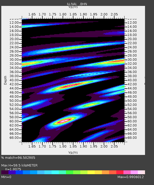
| Estimated Moho Depth: |
59.5 km |
| Estimated Crust Vp/Vs: |
1.81 |
| Assumed Crust Vp: |
6.601 km/s |
| Estimated Crust Vs: |
3.652 km/s |
| Estimated Crust Poisson's Ratio: |
0.28 |
|
| Radial Match: |
96.582985 % |
| Radial Bump: |
400 |
| Transverse Match: |
88.440796 % |
| Transverse Bump: |
400 |
| SOD ConfigId: |
6273 |
| Insert Time: |
2010-03-04 20:55:56.915 +0000 |
| GWidth: |
2.5 |
| Max Bumps: |
400 |
| Tol: |
0.001 |
|

Signal To Noise
| Channel | StoN | STA | LTA |
| IU:NAI: :BHN:19950505T04:06:07.003015Z | 1.5410272 | 1.3329971E-7 | 8.6500556E-8 |
| IU:NAI: :BHE:19950505T04:06:07.003015Z | 1.1988498 | 1.4207126E-7 | 1.185063E-7 |
| IU:NAI: :BHZ:19950505T04:06:07.003015Z | 2.3811028 | 2.822385E-7 | 1.18532675E-7 |
| Arrivals |
| Ps | 7.4 SECOND |
| PpPs | 25 SECOND |
| PsPs/PpSs | 32 SECOND |


