You are here: Home > Network List > IU - Global Seismograph Network (GSN - IRIS/USGS) Stations List
> Station NAI Nairobi, Kenya > Earthquake Result Viewer
NAI Nairobi, Kenya - Earthquake Result Viewer
| Earthquake location: |
Myanmar-India Border Region |
| Earthquake latitude/longitude: |
25.0/95.3 |
| Earthquake time(UTC): |
1995/05/06 (126) 01:59:07 GMT |
| Earthquake Depth: |
122 km |
| Earthquake Magnitude: |
6.4 MB, 6.5 UNKNOWN, 6.4 MW |
| Earthquake Catalog/Contributor: |
WHDF/NEIC |
|
| Network: |
IU Global Seismograph Network (GSN - IRIS/USGS) |
| Station: |
NAI Nairobi, Kenya |
| Lat/Lon: |
1.27 S/36.80 E |
| Elevation: |
1692 m |
|
| Distance: |
62.3 deg |
| Az: |
254.315 deg |
| Baz: |
60.899 deg |
| Ray Param: |
0.059943516 |
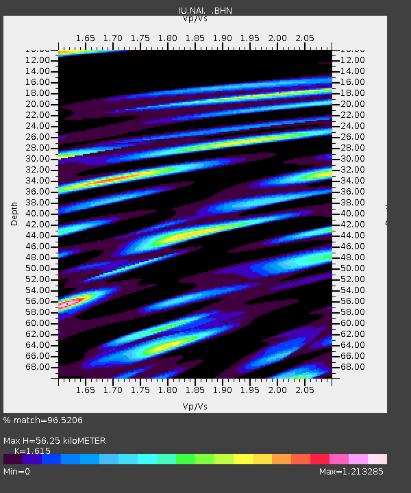
| Estimated Moho Depth: |
56.25 km |
| Estimated Crust Vp/Vs: |
1.62 |
| Assumed Crust Vp: |
6.601 km/s |
| Estimated Crust Vs: |
4.087 km/s |
| Estimated Crust Poisson's Ratio: |
0.19 |
|
| Radial Match: |
96.5206 % |
| Radial Bump: |
400 |
| Transverse Match: |
89.20603 % |
| Transverse Bump: |
400 |
| SOD ConfigId: |
6273 |
| Insert Time: |
2010-03-04 20:55:58.512 +0000 |
| GWidth: |
2.5 |
| Max Bumps: |
400 |
| Tol: |
0.001 |
|

Signal To Noise
| Channel | StoN | STA | LTA |
| IU:NAI: :BHN:19950506T02:08:46.302002Z | 2.8551023 | 3.329345E-7 | 1.1661036E-7 |
| IU:NAI: :BHE:19950506T02:08:46.302002Z | 9.105959 | 7.0748956E-7 | 7.7695226E-8 |
| IU:NAI: :BHZ:19950506T02:08:46.302002Z | 11.810837 | 1.3427548E-6 | 1.13688365E-7 |
| Arrivals |
| Ps | 5.5 SECOND |
| PpPs | 21 SECOND |
| PsPs/PpSs | 27 SECOND |


