You are here: Home > Network List > IU - Global Seismograph Network (GSN - IRIS/USGS) Stations List
> Station NAI Nairobi, Kenya > Earthquake Result Viewer
NAI Nairobi, Kenya - Earthquake Result Viewer
| Earthquake location: |
Samar, Philippines |
| Earthquake latitude/longitude: |
11.6/125.9 |
| Earthquake time(UTC): |
1995/05/08 (128) 18:08:09 GMT |
| Earthquake Depth: |
33 km |
| Earthquake Magnitude: |
5.6 MB, 6.2 MS, 6.3 UNKNOWN, 6.3 MW |
| Earthquake Catalog/Contributor: |
WHDF/NEIC |
|
| Network: |
IU Global Seismograph Network (GSN - IRIS/USGS) |
| Station: |
NAI Nairobi, Kenya |
| Lat/Lon: |
1.27 S/36.80 E |
| Elevation: |
1692 m |
|
| Distance: |
89.4 deg |
| Az: |
268.58 deg |
| Baz: |
78.491 deg |
| Ray Param: |
0.041861236 |
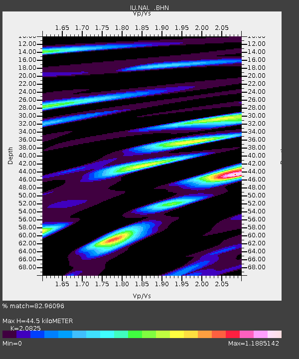
| Estimated Moho Depth: |
44.5 km |
| Estimated Crust Vp/Vs: |
2.08 |
| Assumed Crust Vp: |
6.601 km/s |
| Estimated Crust Vs: |
3.17 km/s |
| Estimated Crust Poisson's Ratio: |
0.35 |
|
| Radial Match: |
82.96096 % |
| Radial Bump: |
400 |
| Transverse Match: |
67.07106 % |
| Transverse Bump: |
400 |
| SOD ConfigId: |
6273 |
| Insert Time: |
2010-03-04 20:55:59.795 +0000 |
| GWidth: |
2.5 |
| Max Bumps: |
400 |
| Tol: |
0.001 |
|
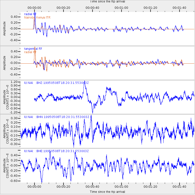
Signal To Noise
| Channel | StoN | STA | LTA |
| IU:NAI: :BHN:19950508T18:20:31.553003Z | 1.1713943 | 8.142062E-8 | 6.950744E-8 |
| IU:NAI: :BHE:19950508T18:20:31.553003Z | 1.8387085 | 2.0185075E-7 | 1.09778554E-7 |
| IU:NAI: :BHZ:19950508T18:20:31.553003Z | 3.4807258 | 4.82505E-7 | 1.3862196E-7 |
| Arrivals |
| Ps | 7.4 SECOND |
| PpPs | 20 SECOND |
| PsPs/PpSs | 28 SECOND |


