You are here: Home > Network List > PF - Volcanologic Network of Piton de Fournaise-OVPF Stations List
> Station CIL Cilaos (Pompiers) > Earthquake Result Viewer
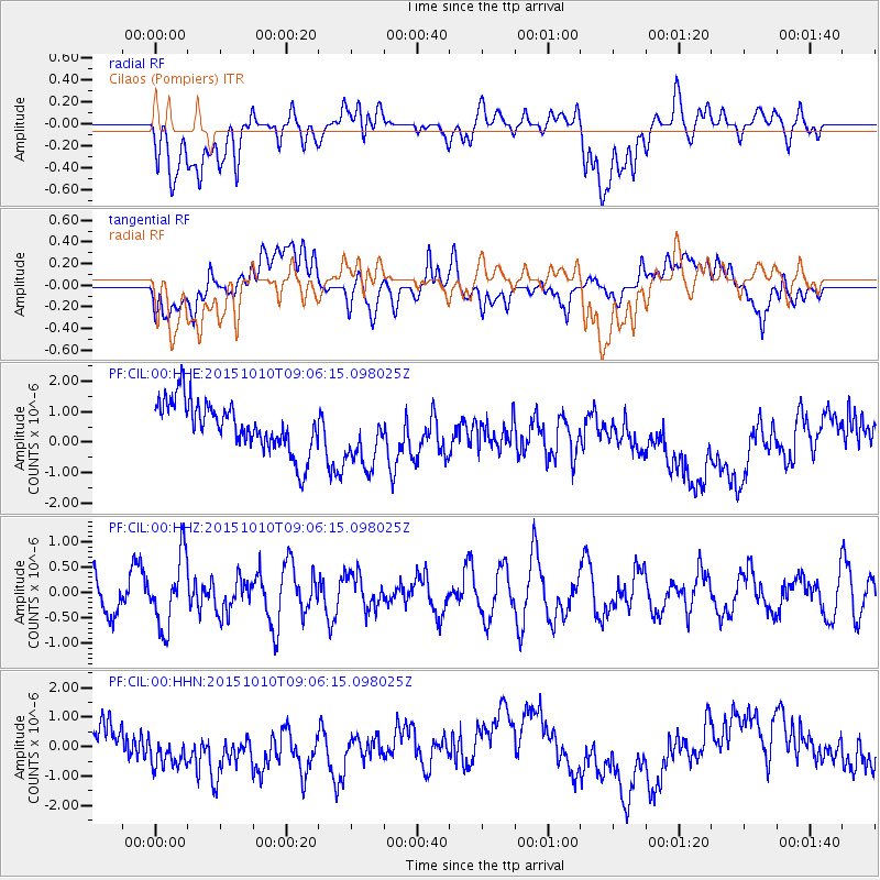
CIL Cilaos (Pompiers) - Earthquake Result Viewer
*The percent match for this event was below the threshold and hence no stack was calculated.
| Earthquake location: |
East Of South Sandwich Islands |
| Earthquake latitude/longitude: |
-60.7/-20.8 |
| Earthquake time(UTC): |
2015/10/10 (283) 08:56:05 GMT |
| Earthquake Depth: |
10 km |
| Earthquake Magnitude: |
5.5 MB |
| Earthquake Catalog/Contributor: |
NEIC PDE/NEIC COMCAT |
|
| Network: |
PF Volcanologic Network of Piton de Fournaise-OVPF |
| Station: |
CIL Cilaos (Pompiers) |
| Lat/Lon: |
21.13 S/55.47 E |
| Elevation: |
1223 m |
|
| Distance: |
65.1 deg |
| Az: |
88.961 deg |
| Baz: |
211.751 deg |
| Ray Param: |
$rayparam |
*The percent match for this event was below the threshold and hence was not used in the summary stack. |
|
| Radial Match: |
26.443464 % |
| Radial Bump: |
400 |
| Transverse Match: |
23.256905 % |
| Transverse Bump: |
400 |
| SOD ConfigId: |
7422571 |
| Insert Time: |
2019-04-21 02:24:48.695 +0000 |
| GWidth: |
2.5 |
| Max Bumps: |
400 |
| Tol: |
0.001 |
|
Signal To Noise
| Channel | StoN | STA | LTA |
| PF:CIL:00:HHZ:20151010T09:06:15.098025Z | 1.6713296 | 6.948184E-7 | 4.1572795E-7 |
| PF:CIL:00:HHN:20151010T09:06:15.098025Z | 1.346603 | 1.0827487E-6 | 8.0405925E-7 |
| PF:CIL:00:HHE:20151010T09:06:15.098025Z | 1.3054607 | 1.0601268E-6 | 8.12071E-7 |
| Arrivals |
| Ps | |
| PpPs | |
| PsPs/PpSs | |


