You are here: Home > Network List > IU - Global Seismograph Network (GSN - IRIS/USGS) Stations List
> Station NAI Nairobi, Kenya > Earthquake Result Viewer
NAI Nairobi, Kenya - Earthquake Result Viewer
| Earthquake location: |
Timor Region |
| Earthquake latitude/longitude: |
-8.4/125.1 |
| Earthquake time(UTC): |
1995/05/14 (134) 11:33:21 GMT |
| Earthquake Depth: |
33 km |
| Earthquake Magnitude: |
6.1 MB, 6.9 MS, 7.1 UNKNOWN, 6.9 MW |
| Earthquake Catalog/Contributor: |
WHDF/NEIC |
|
| Network: |
IU Global Seismograph Network (GSN - IRIS/USGS) |
| Station: |
NAI Nairobi, Kenya |
| Lat/Lon: |
1.27 S/36.80 E |
| Elevation: |
1692 m |
|
| Distance: |
88.1 deg |
| Az: |
268.997 deg |
| Baz: |
98.305 deg |
| Ray Param: |
0.042784646 |
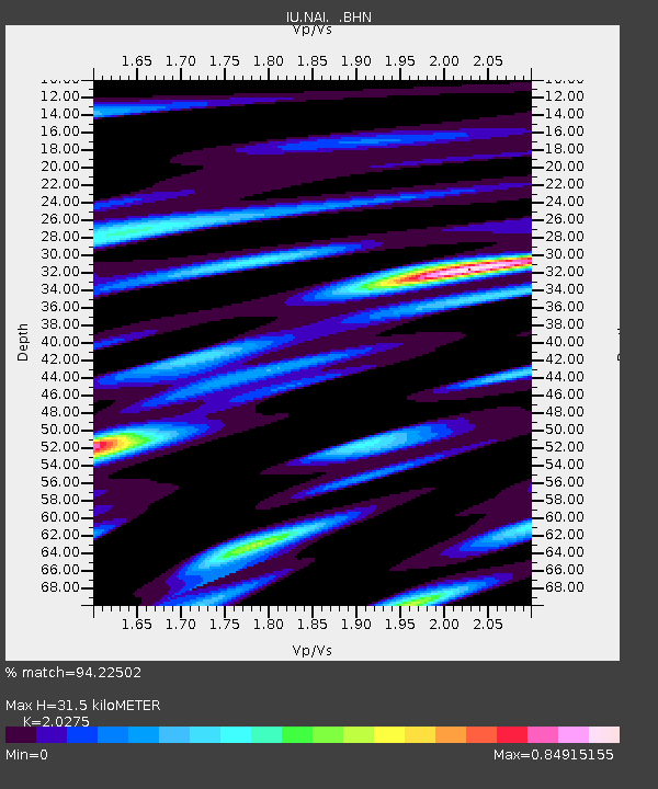
| Estimated Moho Depth: |
31.5 km |
| Estimated Crust Vp/Vs: |
2.03 |
| Assumed Crust Vp: |
6.601 km/s |
| Estimated Crust Vs: |
3.256 km/s |
| Estimated Crust Poisson's Ratio: |
0.34 |
|
| Radial Match: |
94.22502 % |
| Radial Bump: |
400 |
| Transverse Match: |
88.58432 % |
| Transverse Bump: |
400 |
| SOD ConfigId: |
6273 |
| Insert Time: |
2010-03-04 20:56:01.215 +0000 |
| GWidth: |
2.5 |
| Max Bumps: |
400 |
| Tol: |
0.001 |
|
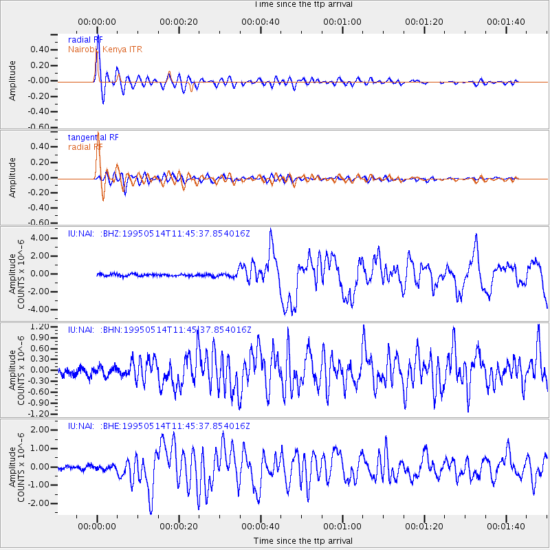
Signal To Noise
| Channel | StoN | STA | LTA |
| IU:NAI: :BHN:19950514T11:45:37.854016Z | 1.4491012 | 1.2092326E-7 | 8.344707E-8 |
| IU:NAI: :BHE:19950514T11:45:37.854016Z | 1.1900378 | 9.9389474E-8 | 8.351792E-8 |
| IU:NAI: :BHZ:19950514T11:45:37.854016Z | 2.4944158 | 2.8588175E-7 | 1.146087E-7 |
| Arrivals |
| Ps | 5.0 SECOND |
| PpPs | 14 SECOND |
| PsPs/PpSs | 19 SECOND |


