You are here: Home > Network List > YT07 - POLENET Stations List
> Station RMBO RMBO > Earthquake Result Viewer
RMBO RMBO - Earthquake Result Viewer
| Earthquake location: |
Pacific-Antarctic Ridge |
| Earthquake latitude/longitude: |
-54.6/-135.8 |
| Earthquake time(UTC): |
2015/10/11 (284) 00:58:27 GMT |
| Earthquake Depth: |
10 km |
| Earthquake Magnitude: |
5.5 MB |
| Earthquake Catalog/Contributor: |
NEIC PDE/NEIC COMCAT |
|
| Network: |
YT POLENET |
| Station: |
RMBO RMBO |
| Lat/Lon: |
83.87 S/66.40 W |
| Elevation: |
800 m |
|
| Distance: |
33.9 deg |
| Az: |
169.599 deg |
| Baz: |
282.03 deg |
| Ray Param: |
0.07801036 |
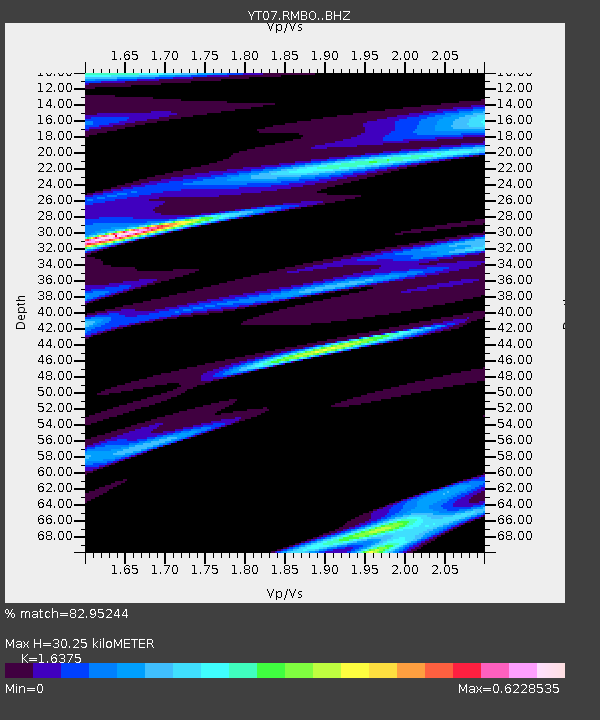
| Estimated Moho Depth: |
30.25 km |
| Estimated Crust Vp/Vs: |
1.64 |
| Assumed Crust Vp: |
6.356 km/s |
| Estimated Crust Vs: |
3.882 km/s |
| Estimated Crust Poisson's Ratio: |
0.20 |
|
| Radial Match: |
82.95244 % |
| Radial Bump: |
350 |
| Transverse Match: |
79.34443 % |
| Transverse Bump: |
391 |
| SOD ConfigId: |
7422571 |
| Insert Time: |
2019-04-21 02:30:40.794 +0000 |
| GWidth: |
2.5 |
| Max Bumps: |
400 |
| Tol: |
0.001 |
|

Signal To Noise
| Channel | StoN | STA | LTA |
| YT:RMBO: :BHZ:20151011T01:04:39.774004Z | 5.3637133 | 7.9938127E-7 | 1.4903505E-7 |
| YT:RMBO: :BHN:20151011T01:04:39.774004Z | 1.5363282 | 2.9880042E-7 | 1.9448996E-7 |
| YT:RMBO: :BHE:20151011T01:04:39.774004Z | 2.6091785 | 5.272221E-7 | 2.020644E-7 |
| Arrivals |
| Ps | 3.3 SECOND |
| PpPs | 12 SECOND |
| PsPs/PpSs | 15 SECOND |


