You are here: Home > Network List > IU - Global Seismograph Network (GSN - IRIS/USGS) Stations List
> Station PTGA Pitinga, Brazil > Earthquake Result Viewer
PTGA Pitinga, Brazil - Earthquake Result Viewer

| Earthquake location: |
Mexico-Guatemala Border Region |
| Earthquake latitude/longitude: |
15.8/-93.0 |
| Earthquake time(UTC): |
1996/12/31 (366) 12:41:42 GMT |
| Earthquake Depth: |
100 km |
| Earthquake Magnitude: |
5.4 MB, 6.3 UNKNOWN, 6.3 MW |
| Earthquake Catalog/Contributor: |
WHDF/NEIC |
|
| Network: |
IU Global Seismograph Network (GSN - IRIS/USGS) |
| Station: |
PTGA Pitinga, Brazil |
| Lat/Lon: |
0.73 S/59.97 W |
| Elevation: |
237 m |
|
| Distance: |
36.5 deg |
| Az: |
113.738 deg |
| Baz: |
298.214 deg |
| Ray Param: |
0.07631858 |
| Estimated Moho Depth: |
53.75 km |
| Estimated Crust Vp/Vs: |
1.74 |
| Assumed Crust Vp: |
6.498 km/s |
| Estimated Crust Vs: |
3.729 km/s |
| Estimated Crust Poisson's Ratio: |
0.25 |
|
| Radial Match: |
90.97584 % |
| Radial Bump: |
263 |
| Transverse Match: |
76.46779 % |
| Transverse Bump: |
400 |
| SOD ConfigId: |
6273 |
| Insert Time: |
2010-03-04 20:56:23.701 +0000 |
| GWidth: |
2.5 |
| Max Bumps: |
400 |
| Tol: |
0.001 |
|
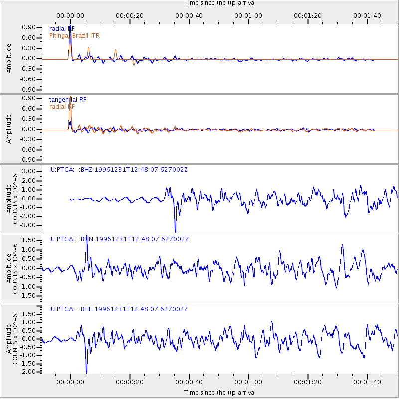
Signal To Noise
| Channel | StoN | STA | LTA |
| IU:PTGA: :BHN:19961231T12:48:07.627002Z | 3.176335 | 2.796199E-7 | 8.803225E-8 |
| IU:PTGA: :BHE:19961231T12:48:07.627002Z | 2.6677532 | 3.2132897E-7 | 1.2044929E-7 |
| IU:PTGA: :BHZ:19961231T12:48:07.627002Z | 3.7935023 | 5.861282E-7 | 1.5450846E-7 |
| Arrivals |
| Ps | 6.6 SECOND |
| PpPs | 21 SECOND |
| PsPs/PpSs | 28 SECOND |


