You are here: Home > Network List > IU - Global Seismograph Network (GSN - IRIS/USGS) Stations List
> Station PTGA Pitinga, Brazil > Earthquake Result Viewer
PTGA Pitinga, Brazil - Earthquake Result Viewer

| Earthquake location: |
Southern Pacific Ocean |
| Earthquake latitude/longitude: |
-36.0/-102.5 |
| Earthquake time(UTC): |
1997/05/29 (149) 17:02:38 GMT |
| Earthquake Depth: |
10 km |
| Earthquake Magnitude: |
5.6 MB, 6.1 MS, 6.5 UNKNOWN, 6.4 MW |
| Earthquake Catalog/Contributor: |
WHDF/NEIC |
|
| Network: |
IU Global Seismograph Network (GSN - IRIS/USGS) |
| Station: |
PTGA Pitinga, Brazil |
| Lat/Lon: |
0.73 S/59.97 W |
| Elevation: |
237 m |
|
| Distance: |
52.8 deg |
| Az: |
58.123 deg |
| Baz: |
223.548 deg |
| Ray Param: |
0.06654885 |
| Estimated Moho Depth: |
34.25 km |
| Estimated Crust Vp/Vs: |
2.10 |
| Assumed Crust Vp: |
6.498 km/s |
| Estimated Crust Vs: |
3.098 km/s |
| Estimated Crust Poisson's Ratio: |
0.35 |
|
| Radial Match: |
94.26738 % |
| Radial Bump: |
362 |
| Transverse Match: |
82.59682 % |
| Transverse Bump: |
400 |
| SOD ConfigId: |
6273 |
| Insert Time: |
2010-03-04 20:56:31.756 +0000 |
| GWidth: |
2.5 |
| Max Bumps: |
400 |
| Tol: |
0.001 |
|
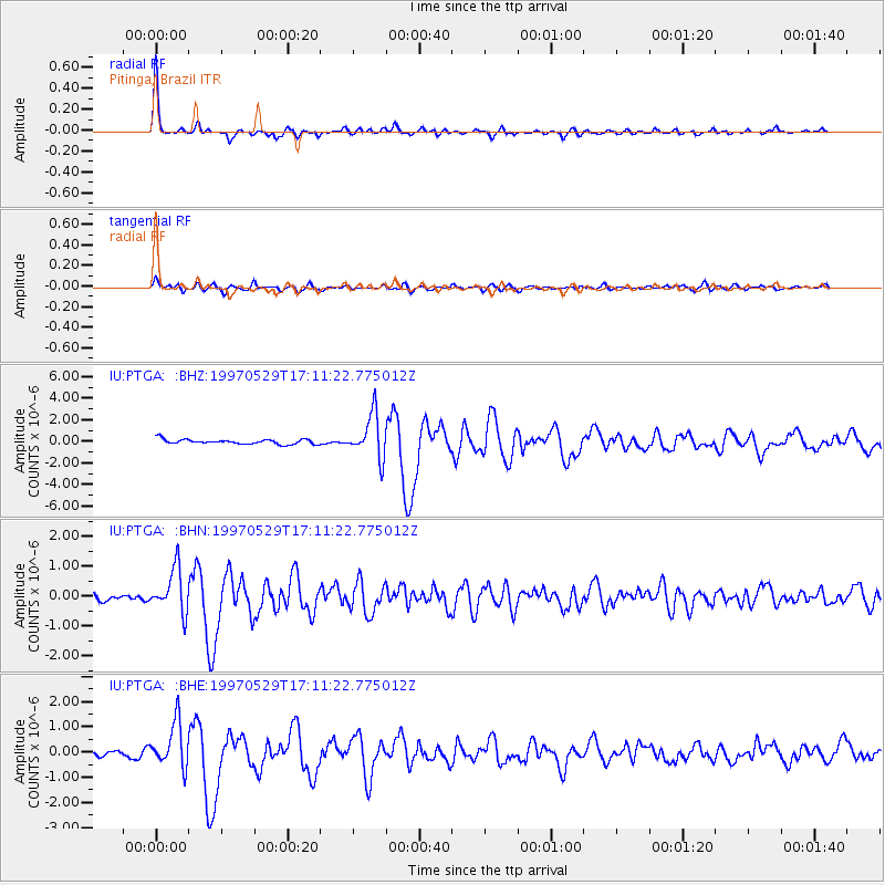
Signal To Noise
| Channel | StoN | STA | LTA |
| IU:PTGA: :BHN:19970529T17:11:22.775012Z | 6.527677 | 7.328247E-7 | 1.1226423E-7 |
| IU:PTGA: :BHE:19970529T17:11:22.775012Z | 6.12612 | 8.8919575E-7 | 1.4514828E-7 |
| IU:PTGA: :BHZ:19970529T17:11:22.775012Z | 9.0071945 | 2.0046225E-6 | 2.2255793E-7 |
| Arrivals |
| Ps | 6.1 SECOND |
| PpPs | 16 SECOND |
| PsPs/PpSs | 22 SECOND |


