You are here: Home > Network List > TA - USArray Transportable Network (new EarthScope stations) Stations List
> Station MSTX Muleshoe, TX, USA > Earthquake Result Viewer
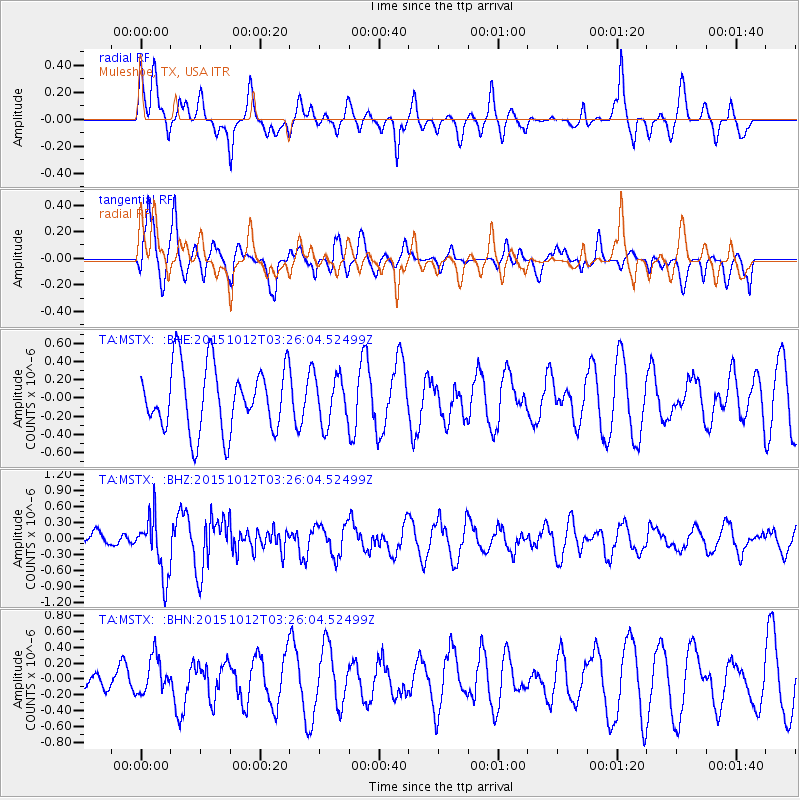
MSTX Muleshoe, TX, USA - Earthquake Result Viewer
*The percent match for this event was below the threshold and hence no stack was calculated.
| Earthquake location: |
Near Coast Of Central Chile |
| Earthquake latitude/longitude: |
-31.2/-71.8 |
| Earthquake time(UTC): |
2015/10/12 (285) 03:15:19 GMT |
| Earthquake Depth: |
21 km |
| Earthquake Magnitude: |
5.6 MWW, 5.3 MWR, 5.5 MWB |
| Earthquake Catalog/Contributor: |
NEIC PDE/NEIC COMCAT |
|
| Network: |
TA USArray Transportable Network (new EarthScope stations) |
| Station: |
MSTX Muleshoe, TX, USA |
| Lat/Lon: |
33.97 N/102.77 W |
| Elevation: |
1167 m |
|
| Distance: |
71.1 deg |
| Az: |
333.139 deg |
| Baz: |
152.229 deg |
| Ray Param: |
$rayparam |
*The percent match for this event was below the threshold and hence was not used in the summary stack. |
|
| Radial Match: |
56.05634 % |
| Radial Bump: |
400 |
| Transverse Match: |
74.00896 % |
| Transverse Bump: |
400 |
| SOD ConfigId: |
7422571 |
| Insert Time: |
2019-04-21 02:36:04.923 +0000 |
| GWidth: |
2.5 |
| Max Bumps: |
400 |
| Tol: |
0.001 |
|
Signal To Noise
| Channel | StoN | STA | LTA |
| TA:MSTX: :BHZ:20151012T03:26:04.52499Z | 3.4066498 | 5.572246E-7 | 1.6356968E-7 |
| TA:MSTX: :BHN:20151012T03:26:04.52499Z | 0.9496414 | 2.314572E-7 | 2.4373117E-7 |
| TA:MSTX: :BHE:20151012T03:26:04.52499Z | 0.7299142 | 2.5829783E-7 | 3.5387424E-7 |
| Arrivals |
| Ps | |
| PpPs | |
| PsPs/PpSs | |


