You are here: Home > Network List > TA - USArray Transportable Network (new EarthScope stations) Stations List
> Station Q61A Milford, DE, USA > Earthquake Result Viewer
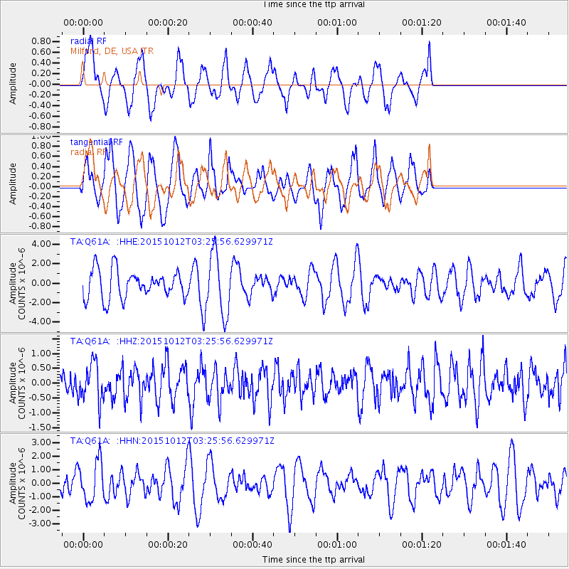
Q61A Milford, DE, USA - Earthquake Result Viewer
*The percent match for this event was below the threshold and hence no stack was calculated.
| Earthquake location: |
Near Coast Of Central Chile |
| Earthquake latitude/longitude: |
-31.2/-71.8 |
| Earthquake time(UTC): |
2015/10/12 (285) 03:15:19 GMT |
| Earthquake Depth: |
21 km |
| Earthquake Magnitude: |
5.6 MWW, 5.3 MWR, 5.5 MWB |
| Earthquake Catalog/Contributor: |
NEIC PDE/NEIC COMCAT |
|
| Network: |
TA USArray Transportable Network (new EarthScope stations) |
| Station: |
Q61A Milford, DE, USA |
| Lat/Lon: |
38.88 N/75.33 W |
| Elevation: |
5.0 m |
|
| Distance: |
69.8 deg |
| Az: |
357.087 deg |
| Baz: |
176.801 deg |
| Ray Param: |
$rayparam |
*The percent match for this event was below the threshold and hence was not used in the summary stack. |
|
| Radial Match: |
48.474728 % |
| Radial Bump: |
400 |
| Transverse Match: |
52.153767 % |
| Transverse Bump: |
333 |
| SOD ConfigId: |
7422571 |
| Insert Time: |
2019-04-21 02:36:10.627 +0000 |
| GWidth: |
2.5 |
| Max Bumps: |
400 |
| Tol: |
0.001 |
|
Signal To Noise
| Channel | StoN | STA | LTA |
| TA:Q61A: :HHZ:20151012T03:25:56.629971Z | 1.2803935 | 6.492402E-7 | 5.07063E-7 |
| TA:Q61A: :HHN:20151012T03:25:56.629971Z | 1.1066921 | 1.4719178E-6 | 1.3300156E-6 |
| TA:Q61A: :HHE:20151012T03:25:56.629971Z | 2.1891797 | 3.1556456E-6 | 1.4414741E-6 |
| Arrivals |
| Ps | |
| PpPs | |
| PsPs/PpSs | |


