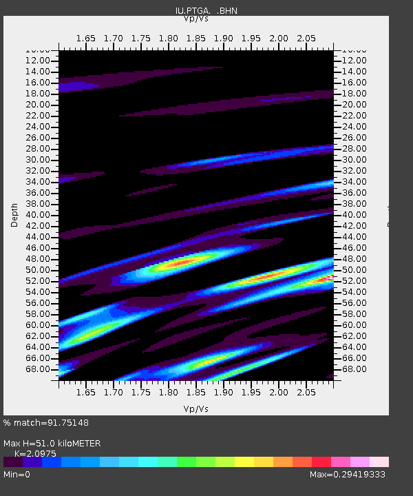
PTGA Pitinga, Brazil - Earthquake Result Viewer
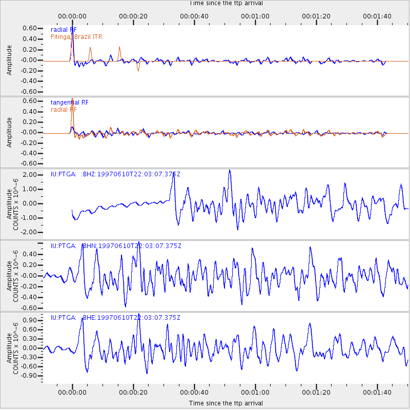
Earthquake location: Southern East Pacific Rise
Earthquake latitude/longitude: -35.8/-108.1
Earthquake time(UTC): 1997/06/10 (161) 21:53:55 GMT
Earthquake Depth: 10 km
Earthquake Magnitude: 5.8 MB, 6.1 MS, 6.5 UNKNOWN, 5.8 MS
Earthquake Catalog/Contributor: WHDF/NEIC
Network: IU Global Seismograph Network (GSN - IRIS/USGS)
Station: PTGA Pitinga, Brazil
Lat/Lon: 0.73 S/59.97 W
Elevation: 237 m
Distance: 56.7 deg
Az: 63.085 deg
Baz: 226.451 deg
Ray Param: 0.063987955
Estimated Moho Depth: 51.0 km
Estimated Crust Vp/Vs: 2.10
Assumed Crust Vp: 6.498 km/s
Estimated Crust Vs: 3.098 km/s
Estimated Crust Poisson's Ratio: 0.35
Radial Match: 91.75148 %
Radial Bump: 293
Transverse Match: 76.560295 %
Transverse Bump: 400
SOD ConfigId: 6273
Insert Time: 2010-03-04 20:56:35.156 +0000
GWidth: 2.5
Max Bumps: 400
Tol: 0.001

Signal To Noise

ChannelStoNSTALTA
IU:PTGA: :BHN:19970610T22:03:07.375Z5.61358262.7096183E-74.826897E-8
IU:PTGA: :BHE:19970610T22:03:07.375Z5.50345374.769172E-78.6657806E-8
IU:PTGA: :BHZ:19970610T22:03:07.375Z3.44862271.0760251E-63.120159E-7
Arrivals
Ps9.0 SECOND
PpPs23 SECOND
PsPs/PpSs32 SECOND