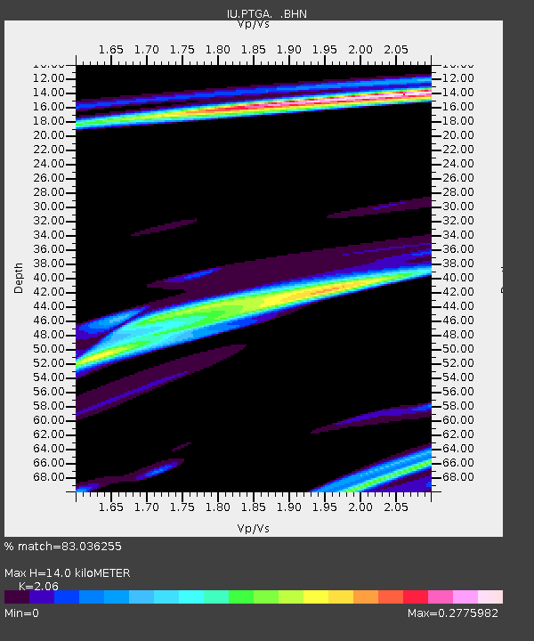
PTGA Pitinga, Brazil - Earthquake Result Viewer

Earthquake location: Near Coast Of Guerrero, Mexico
Earthquake latitude/longitude: 16.3/-98.2
Earthquake time(UTC): 1997/07/19 (200) 14:22:08 GMT
Earthquake Depth: 33 km
Earthquake Magnitude: 5.7 MB, 6.3 MS, 6.8 UNKNOWN, 6.0 ME
Earthquake Catalog/Contributor: WHDF/NEIC
Network: IU Global Seismograph Network (GSN - IRIS/USGS)
Station: PTGA Pitinga, Brazil
Lat/Lon: 0.73 S/59.97 W
Elevation: 237 m
Distance: 41.4 deg
Az: 110.515 deg
Baz: 295.93 deg
Ray Param: 0.07376567
Estimated Moho Depth: 14.0 km
Estimated Crust Vp/Vs: 2.06
Assumed Crust Vp: 6.498 km/s
Estimated Crust Vs: 3.154 km/s
Estimated Crust Poisson's Ratio: 0.35
Radial Match: 83.036255 %
Radial Bump: 284
Transverse Match: 73.37236 %
Transverse Bump: 400
SOD ConfigId: 6273
Insert Time: 2010-03-04 20:56:36.223 +0000
GWidth: 2.5
Max Bumps: 400
Tol: 0.001

Signal To Noise

ChannelStoNSTALTA
IU:PTGA: :BHN:19970719T14:29:21.189014Z1.48049651.04779055E-77.077291E-8
IU:PTGA: :BHE:19970719T14:29:21.189014Z2.3727421.8728066E-77.8930064E-8
IU:PTGA: :BHZ:19970719T14:29:21.189014Z0.693659256.143639E-78.8568544E-7
Arrivals
Ps2.4 SECOND
PpPs6.2 SECOND
PsPs/PpSs8.6 SECOND