You are here: Home > Network List > IU - Global Seismograph Network (GSN - IRIS/USGS) Stations List
> Station PTGA Pitinga, Brazil > Earthquake Result Viewer
PTGA Pitinga, Brazil - Earthquake Result Viewer
| Earthquake location: |
Pacific-Antarctic Ridge |
| Earthquake latitude/longitude: |
-55.2/-129.0 |
| Earthquake time(UTC): |
1997/09/03 (246) 06:22:44 GMT |
| Earthquake Depth: |
10 km |
| Earthquake Magnitude: |
5.1 MB, 6.0 MS, 6.1 UNKNOWN, 6.0 MW |
| Earthquake Catalog/Contributor: |
WHDF/NEIC |
|
| Network: |
IU Global Seismograph Network (GSN - IRIS/USGS) |
| Station: |
PTGA Pitinga, Brazil |
| Lat/Lon: |
0.73 S/59.97 W |
| Elevation: |
237 m |
|
| Distance: |
77.5 deg |
| Az: |
72.969 deg |
| Baz: |
213.253 deg |
| Ray Param: |
0.05024914 |
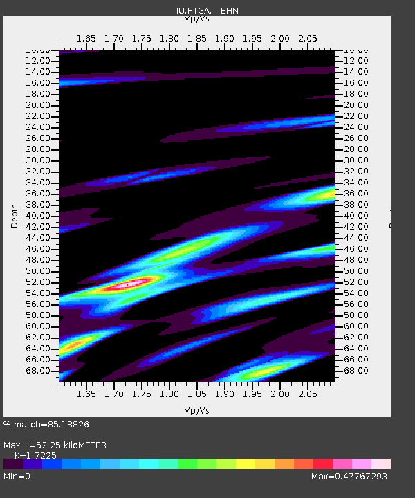
| Estimated Moho Depth: |
52.25 km |
| Estimated Crust Vp/Vs: |
1.72 |
| Assumed Crust Vp: |
6.498 km/s |
| Estimated Crust Vs: |
3.772 km/s |
| Estimated Crust Poisson's Ratio: |
0.25 |
|
| Radial Match: |
85.18826 % |
| Radial Bump: |
360 |
| Transverse Match: |
61.223038 % |
| Transverse Bump: |
400 |
| SOD ConfigId: |
6273 |
| Insert Time: |
2010-03-04 20:56:40.934 +0000 |
| GWidth: |
2.5 |
| Max Bumps: |
400 |
| Tol: |
0.001 |
|
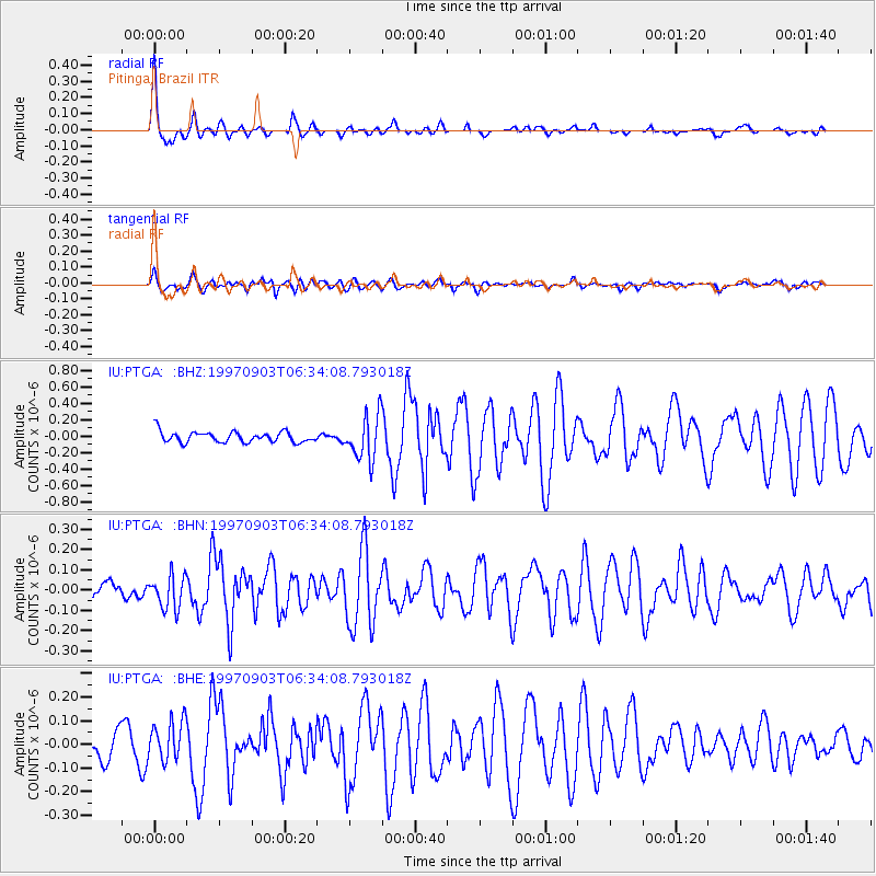
Signal To Noise
| Channel | StoN | STA | LTA |
| IU:PTGA: :BHN:19970903T06:34:08.793018Z | 2.0168538 | 8.069338E-8 | 4.0009535E-8 |
| IU:PTGA: :BHE:19970903T06:34:08.793018Z | 1.6629796 | 8.416011E-8 | 5.0608026E-8 |
| IU:PTGA: :BHZ:19970903T06:34:08.793018Z | 4.0942063 | 2.7043134E-7 | 6.60522E-8 |
| Arrivals |
| Ps | 6.0 SECOND |
| PpPs | 21 SECOND |
| PsPs/PpSs | 27 SECOND |


