You are here: Home > Network List > IU - Global Seismograph Network (GSN - IRIS/USGS) Stations List
> Station PTGA Pitinga, Brazil > Earthquake Result Viewer
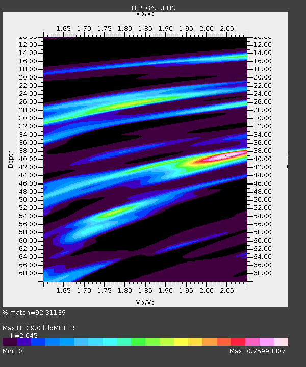
PTGA Pitinga, Brazil - Earthquake Result Viewer
| Earthquake location: |
El Salvador |
| Earthquake latitude/longitude: |
13.8/-88.8 |
| Earthquake time(UTC): |
1997/11/09 (313) 22:56:42 GMT |
| Earthquake Depth: |
176 km |
| Earthquake Magnitude: |
5.6 MB, 6.4 UNKNOWN, 5.0 MD |
| Earthquake Catalog/Contributor: |
WHDF/NEIC |
|
| Network: |
IU Global Seismograph Network (GSN - IRIS/USGS) |
| Station: |
PTGA Pitinga, Brazil |
| Lat/Lon: |
0.73 S/59.97 W |
| Elevation: |
237 m |
|
| Distance: |
32.0 deg |
| Az: |
114.581 deg |
| Baz: |
297.951 deg |
| Ray Param: |
0.07829701 |
| Estimated Moho Depth: |
39.0 km |
| Estimated Crust Vp/Vs: |
2.05 |
| Assumed Crust Vp: |
6.498 km/s |
| Estimated Crust Vs: |
3.177 km/s |
| Estimated Crust Poisson's Ratio: |
0.34 |
|
| Radial Match: |
92.31139 % |
| Radial Bump: |
208 |
| Transverse Match: |
76.48987 % |
| Transverse Bump: |
400 |
| SOD ConfigId: |
6273 |
| Insert Time: |
2010-03-04 20:56:44.820 +0000 |
| GWidth: |
2.5 |
| Max Bumps: |
400 |
| Tol: |
0.001 |
|

Signal To Noise
| Channel | StoN | STA | LTA |
| IU:PTGA: :BHN:19971109T23:02:22.340015Z | 3.3490367 | 3.8524377E-7 | 1.1503121E-7 |
| IU:PTGA: :BHE:19971109T23:02:22.340015Z | 4.559956 | 4.0819026E-7 | 8.951627E-8 |
| IU:PTGA: :BHZ:19971109T23:02:22.340015Z | 8.021964 | 7.691121E-7 | 9.587578E-8 |
| Arrivals |
| Ps | 6.7 SECOND |
| PpPs | 17 SECOND |
| PsPs/PpSs | 24 SECOND |


