You are here: Home > Network List > IU - Global Seismograph Network (GSN - IRIS/USGS) Stations List
> Station PTGA Pitinga, Brazil > Earthquake Result Viewer
PTGA Pitinga, Brazil - Earthquake Result Viewer

| Earthquake location: |
Ionian Sea |
| Earthquake latitude/longitude: |
37.6/20.7 |
| Earthquake time(UTC): |
1997/11/18 (322) 13:07:41 GMT |
| Earthquake Depth: |
33 km |
| Earthquake Magnitude: |
5.9 MB, 6.4 MS, 6.7 UNKNOWN, 6.1 ML |
| Earthquake Catalog/Contributor: |
WHDF/NEIC |
|
| Network: |
IU Global Seismograph Network (GSN - IRIS/USGS) |
| Station: |
PTGA Pitinga, Brazil |
| Lat/Lon: |
0.73 S/59.97 W |
| Elevation: |
237 m |
|
| Distance: |
83.0 deg |
| Az: |
263.696 deg |
| Baz: |
52.171 deg |
| Ray Param: |
0.046449013 |
| Estimated Moho Depth: |
53.5 km |
| Estimated Crust Vp/Vs: |
1.70 |
| Assumed Crust Vp: |
6.498 km/s |
| Estimated Crust Vs: |
3.816 km/s |
| Estimated Crust Poisson's Ratio: |
0.24 |
|
| Radial Match: |
96.76396 % |
| Radial Bump: |
301 |
| Transverse Match: |
91.428215 % |
| Transverse Bump: |
400 |
| SOD ConfigId: |
6273 |
| Insert Time: |
2010-03-04 20:56:46.392 +0000 |
| GWidth: |
2.5 |
| Max Bumps: |
400 |
| Tol: |
0.001 |
|
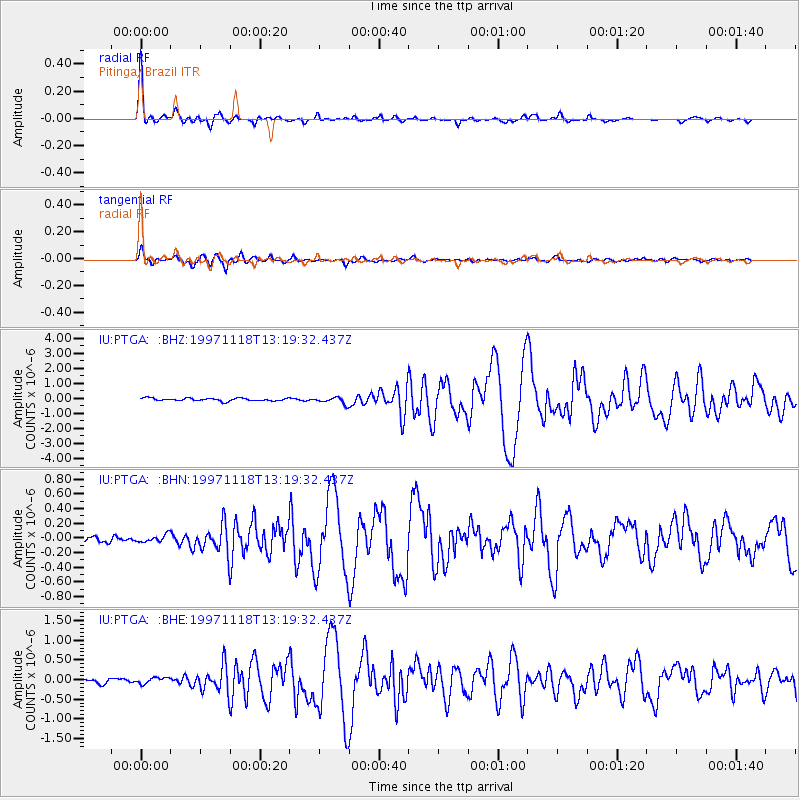
Signal To Noise
| Channel | StoN | STA | LTA |
| IU:PTGA: :BHN:19971118T13:19:32.437Z | 0.99733543 | 5.1556192E-8 | 5.1693934E-8 |
| IU:PTGA: :BHE:19971118T13:19:32.437Z | 1.3154275 | 7.9966114E-8 | 6.079097E-8 |
| IU:PTGA: :BHZ:19971118T13:19:32.437Z | 2.411158 | 2.1560462E-7 | 8.941953E-8 |
| Arrivals |
| Ps | 5.9 SECOND |
| PpPs | 22 SECOND |
| PsPs/PpSs | 28 SECOND |


