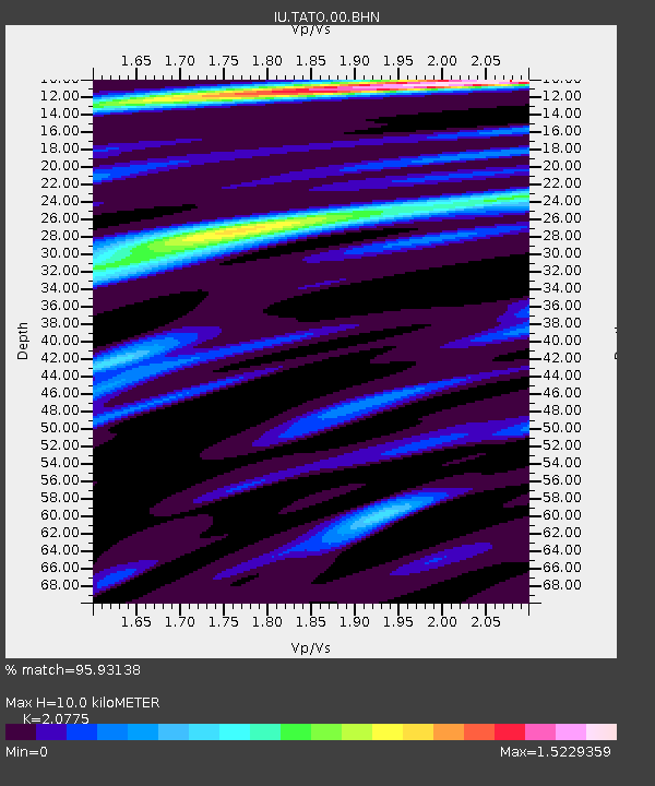
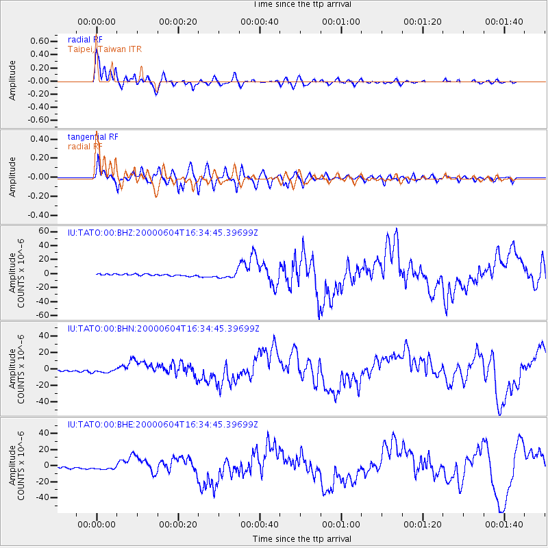
TATO Taipei, Taiwan - Earthquake Result Viewer

Earthquake location: Southern Sumatra, Indonesia
Earthquake latitude/longitude: -4.7/102.1
Earthquake time(UTC): 2000/06/04 (156) 16:28:26 GMT
Earthquake Depth: 33 km
Earthquake Magnitude: 6.8 MB, 8.0 MS, 7.9 MW, 7.7 MW
Earthquake Catalog/Contributor: WHDF/NEIC
Network: IU Global Seismograph Network (GSN - IRIS/USGS)
Station: TATO Taipei, Taiwan
Lat/Lon: 24.98 N/121.49 E
Elevation: 53 m
Distance: 35.0 deg
Az: 31.682 deg
Baz: 215.222 deg
Ray Param: 0.07737593
Estimated Moho Depth: 10.0 km
Estimated Crust Vp/Vs: 2.08
Assumed Crust Vp: 6.289 km/s
Estimated Crust Vs: 3.027 km/s
Estimated Crust Poisson's Ratio: 0.35
Radial Match: 95.93138 %
Radial Bump: 348
Transverse Match: 85.32115 %
Transverse Bump: 400
SOD ConfigId: 3744
Insert Time: 2010-03-04 20:56:57.125 +0000
GWidth: 2.5
Max Bumps: 400
Tol: 0.001

Signal To Noise

ChannelStoNSTALTA
IU:TATO:00:BHN:20000604T16:34:45.39699Z2.62158922.3724872E-69.0498054E-7
IU:TATO:00:BHE:20000604T16:34:45.39699Z2.48251682.3011492E-69.2694205E-7
IU:TATO:00:BHZ:20000604T16:34:45.39699Z3.60505134.3984237E-61.2200725E-6
Arrivals
Ps1.8 SECOND
PpPs4.6 SECOND
PsPs/PpSs6.4 SECOND