You are here: Home > Network List > CB - China National Seismic Network Stations List
> Station LZH Lanzhou,Gansu Province > Earthquake Result Viewer
LZH Lanzhou,Gansu Province - Earthquake Result Viewer
| Earthquake location: |
East Of Kuril Islands |
| Earthquake latitude/longitude: |
48.9/156.2 |
| Earthquake time(UTC): |
2015/10/14 (287) 05:43:07 GMT |
| Earthquake Depth: |
6.0 km |
| Earthquake Magnitude: |
5.6 MB, 5.9 MWB |
| Earthquake Catalog/Contributor: |
NEIC PDE/NEIC COMCAT |
|
| Network: |
CB China National Seismic Network |
| Station: |
LZH Lanzhou,Gansu Province |
| Lat/Lon: |
36.09 N/103.84 E |
| Elevation: |
1560 m |
|
| Distance: |
39.9 deg |
| Az: |
271.456 deg |
| Baz: |
54.606 deg |
| Ray Param: |
0.07469785 |
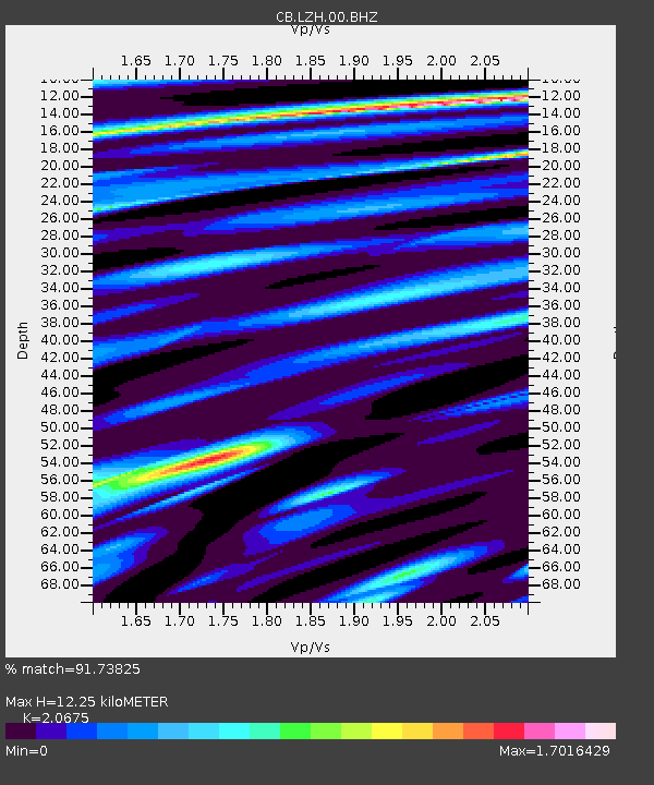
| Estimated Moho Depth: |
12.25 km |
| Estimated Crust Vp/Vs: |
2.07 |
| Assumed Crust Vp: |
6.306 km/s |
| Estimated Crust Vs: |
3.05 km/s |
| Estimated Crust Poisson's Ratio: |
0.35 |
|
| Radial Match: |
91.73825 % |
| Radial Bump: |
400 |
| Transverse Match: |
76.388336 % |
| Transverse Bump: |
400 |
| SOD ConfigId: |
7422571 |
| Insert Time: |
2019-04-21 02:43:10.540 +0000 |
| GWidth: |
2.5 |
| Max Bumps: |
400 |
| Tol: |
0.001 |
|

Signal To Noise
| Channel | StoN | STA | LTA |
| CB:LZH:00:BHZ:20151014T05:50:11.059985Z | 9.061126 | 8.937937E-7 | 9.864047E-8 |
| CB:LZH:00:BHN:20151014T05:50:11.059985Z | 2.4563804 | 3.700013E-7 | 1.5062865E-7 |
| CB:LZH:00:BHE:20151014T05:50:11.059985Z | 4.4954453 | 6.072492E-7 | 1.3508101E-7 |
| Arrivals |
| Ps | 2.2 SECOND |
| PpPs | 5.6 SECOND |
| PsPs/PpSs | 7.8 SECOND |


