You are here: Home > Network List > IU - Global Seismograph Network (GSN - IRIS/USGS) Stations List
> Station TATO Taipei, Taiwan > Earthquake Result Viewer
TATO Taipei, Taiwan - Earthquake Result Viewer

| Earthquake location: |
Solomon Islands |
| Earthquake latitude/longitude: |
-7.4/155.9 |
| Earthquake time(UTC): |
2001/04/19 (109) 21:43:42 GMT |
| Earthquake Depth: |
17 km |
| Earthquake Magnitude: |
6.0 MB, 6.6 MS, 6.7 MW, 6.2 ME |
| Earthquake Catalog/Contributor: |
WHDF/NEIC |
|
| Network: |
IU Global Seismograph Network (GSN - IRIS/USGS) |
| Station: |
TATO Taipei, Taiwan |
| Lat/Lon: |
24.98 N/121.49 E |
| Elevation: |
53 m |
|
| Distance: |
46.4 deg |
| Az: |
314.998 deg |
| Baz: |
129.401 deg |
| Ray Param: |
0.070623904 |
| Estimated Moho Depth: |
28.75 km |
| Estimated Crust Vp/Vs: |
1.67 |
| Assumed Crust Vp: |
6.289 km/s |
| Estimated Crust Vs: |
3.771 km/s |
| Estimated Crust Poisson's Ratio: |
0.22 |
|
| Radial Match: |
88.543846 % |
| Radial Bump: |
400 |
| Transverse Match: |
75.72502 % |
| Transverse Bump: |
400 |
| SOD ConfigId: |
4714 |
| Insert Time: |
2010-03-04 20:57:08.870 +0000 |
| GWidth: |
2.5 |
| Max Bumps: |
400 |
| Tol: |
0.001 |
|
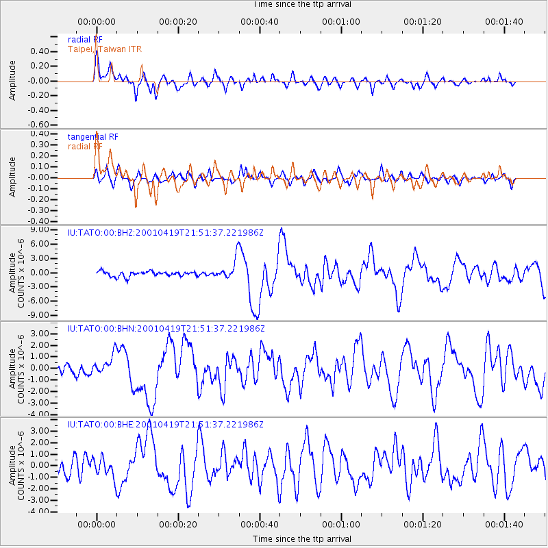
Signal To Noise
| Channel | StoN | STA | LTA |
| IU:TATO:00:BHN:20010419T21:51:37.221986Z | 2.0996575 | 9.502687E-7 | 4.5258273E-7 |
| IU:TATO:00:BHE:20010419T21:51:37.221986Z | 1.251536 | 8.8781275E-7 | 7.093785E-7 |
| IU:TATO:00:BHZ:20010419T21:51:37.221986Z | 4.420862 | 2.3219443E-6 | 5.252243E-7 |
| Arrivals |
| Ps | 3.3 SECOND |
| PpPs | 11 SECOND |
| PsPs/PpSs | 15 SECOND |


