You are here: Home > Network List > LD - Lamont-Doherty Cooperative Seismographic Network Stations List
> Station LUPA Lehigh University, PA > Earthquake Result Viewer
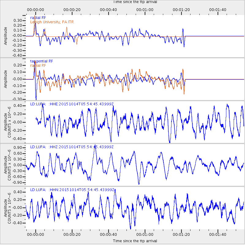
LUPA Lehigh University, PA - Earthquake Result Viewer
*The percent match for this event was below the threshold and hence no stack was calculated.
| Earthquake location: |
East Of Kuril Islands |
| Earthquake latitude/longitude: |
48.9/156.2 |
| Earthquake time(UTC): |
2015/10/14 (287) 05:43:07 GMT |
| Earthquake Depth: |
6.0 km |
| Earthquake Magnitude: |
5.6 MB, 5.9 MWB |
| Earthquake Catalog/Contributor: |
NEIC PDE/NEIC COMCAT |
|
| Network: |
LD Lamont-Doherty Cooperative Seismographic Network |
| Station: |
LUPA Lehigh University, PA |
| Lat/Lon: |
40.60 N/75.37 W |
| Elevation: |
236 m |
|
| Distance: |
80.0 deg |
| Az: |
37.314 deg |
| Baz: |
328.275 deg |
| Ray Param: |
$rayparam |
*The percent match for this event was below the threshold and hence was not used in the summary stack. |
|
| Radial Match: |
62.46979 % |
| Radial Bump: |
400 |
| Transverse Match: |
62.09641 % |
| Transverse Bump: |
400 |
| SOD ConfigId: |
7422571 |
| Insert Time: |
2019-04-21 02:46:09.179 +0000 |
| GWidth: |
2.5 |
| Max Bumps: |
400 |
| Tol: |
0.001 |
|
Signal To Noise
| Channel | StoN | STA | LTA |
| LD:LUPA: :HHZ:20151014T05:54:45.43999Z | 2.186398 | 3.8686758E-7 | 1.7694289E-7 |
| LD:LUPA: :HHN:20151014T05:54:45.43999Z | 1.0816925 | 1.8734329E-7 | 1.7319459E-7 |
| LD:LUPA: :HHE:20151014T05:54:45.43999Z | 1.3506589 | 2.0937023E-7 | 1.5501341E-7 |
| Arrivals |
| Ps | |
| PpPs | |
| PsPs/PpSs | |


