You are here: Home > Network List > TA - USArray Transportable Network (new EarthScope stations) Stations List
> Station A36M Sachs Harbour, NT, CAN > Earthquake Result Viewer
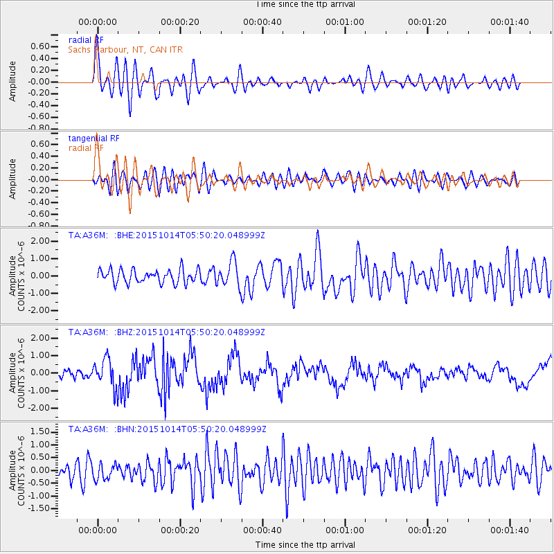
A36M Sachs Harbour, NT, CAN - Earthquake Result Viewer
*The percent match for this event was below the threshold and hence no stack was calculated.
| Earthquake location: |
East Of Kuril Islands |
| Earthquake latitude/longitude: |
48.9/156.2 |
| Earthquake time(UTC): |
2015/10/14 (287) 05:43:07 GMT |
| Earthquake Depth: |
6.0 km |
| Earthquake Magnitude: |
5.6 MB, 5.9 MWB |
| Earthquake Catalog/Contributor: |
NEIC PDE/NEIC COMCAT |
|
| Network: |
TA USArray Transportable Network (new EarthScope stations) |
| Station: |
A36M Sachs Harbour, NT, CAN |
| Lat/Lon: |
71.99 N/125.25 W |
| Elevation: |
32 m |
|
| Distance: |
41.0 deg |
| Az: |
27.68 deg |
| Baz: |
279.515 deg |
| Ray Param: |
$rayparam |
*The percent match for this event was below the threshold and hence was not used in the summary stack. |
|
| Radial Match: |
77.66248 % |
| Radial Bump: |
400 |
| Transverse Match: |
57.966297 % |
| Transverse Bump: |
400 |
| SOD ConfigId: |
7422571 |
| Insert Time: |
2019-04-21 02:48:35.447 +0000 |
| GWidth: |
2.5 |
| Max Bumps: |
400 |
| Tol: |
0.001 |
|
Signal To Noise
| Channel | StoN | STA | LTA |
| TA:A36M: :BHZ:20151014T05:50:20.048999Z | 4.287834 | 8.3520575E-7 | 1.94785E-7 |
| TA:A36M: :BHN:20151014T05:50:20.048999Z | 0.76309735 | 3.0939353E-7 | 4.0544438E-7 |
| TA:A36M: :BHE:20151014T05:50:20.048999Z | 2.12706 | 8.03894E-7 | 3.7793671E-7 |
| Arrivals |
| Ps | |
| PpPs | |
| PsPs/PpSs | |


