You are here: Home > Network List > TM - Thai Seismic Monitoring Network Stations List
> Station CMMT CMMT Chiang-Mai Phase1 > Earthquake Result Viewer
CMMT CMMT Chiang-Mai Phase1 - Earthquake Result Viewer
| Earthquake location: |
East Of Kuril Islands |
| Earthquake latitude/longitude: |
48.9/156.2 |
| Earthquake time(UTC): |
2015/10/14 (287) 05:43:07 GMT |
| Earthquake Depth: |
6.0 km |
| Earthquake Magnitude: |
5.6 MB, 5.9 MWB |
| Earthquake Catalog/Contributor: |
NEIC PDE/NEIC COMCAT |
|
| Network: |
TM Thai Seismic Monitoring Network |
| Station: |
CMMT CMMT Chiang-Mai Phase1 |
| Lat/Lon: |
18.81 N/98.94 E |
| Elevation: |
374 m |
|
| Distance: |
54.6 deg |
| Az: |
257.793 deg |
| Baz: |
42.965 deg |
| Ray Param: |
0.06532859 |
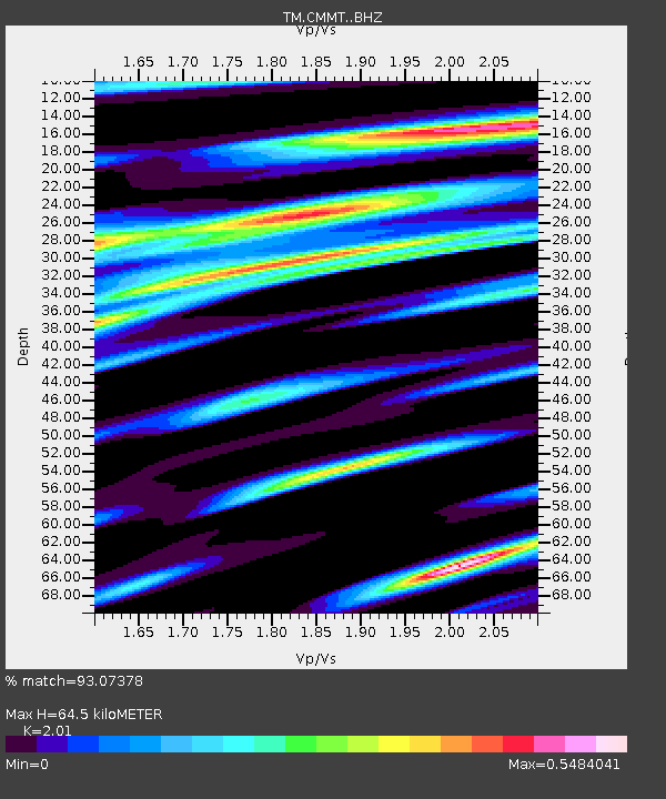
| Estimated Moho Depth: |
64.5 km |
| Estimated Crust Vp/Vs: |
2.01 |
| Assumed Crust Vp: |
6.35 km/s |
| Estimated Crust Vs: |
3.159 km/s |
| Estimated Crust Poisson's Ratio: |
0.34 |
|
| Radial Match: |
93.07378 % |
| Radial Bump: |
400 |
| Transverse Match: |
56.777912 % |
| Transverse Bump: |
400 |
| SOD ConfigId: |
7422571 |
| Insert Time: |
2019-04-21 02:49:06.885 +0000 |
| GWidth: |
2.5 |
| Max Bumps: |
400 |
| Tol: |
0.001 |
|

Signal To Noise
| Channel | StoN | STA | LTA |
| TM:CMMT: :BHZ:20151014T05:52:05.410022Z | 12.982384 | 9.533272E-7 | 7.343237E-8 |
| TM:CMMT: :BHN:20151014T05:52:05.410022Z | 3.6257741 | 3.5499224E-7 | 9.7907986E-8 |
| TM:CMMT: :BHE:20151014T05:52:05.410022Z | 5.4962993 | 2.8997718E-7 | 5.2758626E-8 |
| Arrivals |
| Ps | 11 SECOND |
| PpPs | 29 SECOND |
| PsPs/PpSs | 40 SECOND |


