You are here: Home > Network List > XQ15 - Rapid response to the Mw 7.9 earthquake of April 25, 2015 in Nepal Stations List
> Station NA210 Katmandu,Nepal > Earthquake Result Viewer
NA210 Katmandu,Nepal - Earthquake Result Viewer
| Earthquake location: |
East Of Kuril Islands |
| Earthquake latitude/longitude: |
48.9/156.2 |
| Earthquake time(UTC): |
2015/10/14 (287) 05:43:07 GMT |
| Earthquake Depth: |
6.0 km |
| Earthquake Magnitude: |
5.6 MB, 5.9 MWB |
| Earthquake Catalog/Contributor: |
NEIC PDE/NEIC COMCAT |
|
| Network: |
XQ Rapid response to the Mw 7.9 earthquake of April 25, 2015 in Nepal |
| Station: |
NA210 Katmandu,Nepal |
| Lat/Lon: |
27.74 N/86.16 E |
| Elevation: |
1174 m |
|
| Distance: |
56.8 deg |
| Az: |
275.428 deg |
| Baz: |
47.89 deg |
| Ray Param: |
0.06388886 |
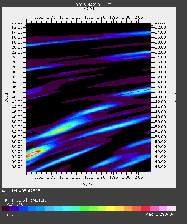
| Estimated Moho Depth: |
62.5 km |
| Estimated Crust Vp/Vs: |
1.62 |
| Assumed Crust Vp: |
6.236 km/s |
| Estimated Crust Vs: |
3.837 km/s |
| Estimated Crust Poisson's Ratio: |
0.20 |
|
| Radial Match: |
85.44585 % |
| Radial Bump: |
400 |
| Transverse Match: |
73.121544 % |
| Transverse Bump: |
400 |
| SOD ConfigId: |
7422571 |
| Insert Time: |
2019-04-21 02:50:55.905 +0000 |
| GWidth: |
2.5 |
| Max Bumps: |
400 |
| Tol: |
0.001 |
|

Signal To Noise
| Channel | StoN | STA | LTA |
| XQ:NA210: :HHZ:20151014T05:52:21.109973Z | 16.322504 | 1.2172753E-6 | 7.4576505E-8 |
| XQ:NA210: :HH1:20151014T05:52:21.109973Z | 7.762766 | 5.2638165E-7 | 6.780852E-8 |
| XQ:NA210: :HH2:20151014T05:52:21.109973Z | 9.11977 | 4.1376052E-7 | 4.536962E-8 |
| Arrivals |
| Ps | 6.6 SECOND |
| PpPs | 25 SECOND |
| PsPs/PpSs | 32 SECOND |


