You are here: Home > Network List > TA - USArray Transportable Network (new EarthScope stations) Stations List
> Station X43A Marvell, AR, USA > Earthquake Result Viewer
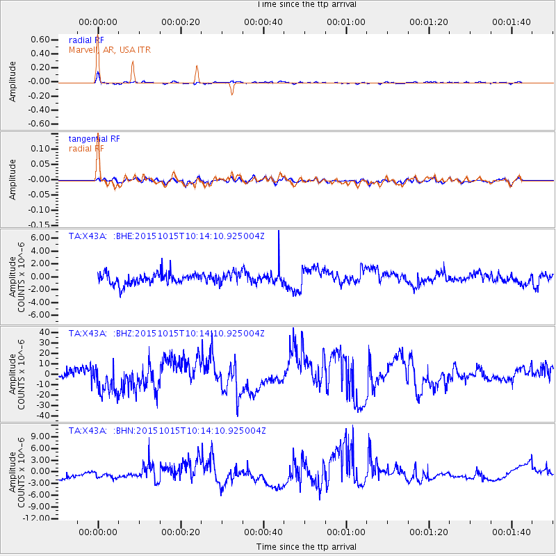
X43A Marvell, AR, USA - Earthquake Result Viewer
*The percent match for this event was below the threshold and hence no stack was calculated.
| Earthquake location: |
Ecuador |
| Earthquake latitude/longitude: |
-2.5/-78.8 |
| Earthquake time(UTC): |
2015/10/15 (288) 10:07:28 GMT |
| Earthquake Depth: |
97 km |
| Earthquake Magnitude: |
5.4 mww |
| Earthquake Catalog/Contributor: |
NEIC PDE/us |
|
| Network: |
TA USArray Transportable Network (new EarthScope stations) |
| Station: |
X43A Marvell, AR, USA |
| Lat/Lon: |
34.52 N/90.88 W |
| Elevation: |
53 m |
|
| Distance: |
38.5 deg |
| Az: |
343.848 deg |
| Baz: |
160.331 deg |
| Ray Param: |
$rayparam |
*The percent match for this event was below the threshold and hence was not used in the summary stack. |
|
| Radial Match: |
67.311066 % |
| Radial Bump: |
390 |
| Transverse Match: |
37.713158 % |
| Transverse Bump: |
400 |
| SOD ConfigId: |
7422571 |
| Insert Time: |
2019-04-21 02:58:03.823 +0000 |
| GWidth: |
2.5 |
| Max Bumps: |
400 |
| Tol: |
0.001 |
|
Signal To Noise
| Channel | StoN | STA | LTA |
| TA:X43A: :BHZ:20151015T10:14:10.925004Z | 1.67646 | 1.5548121E-5 | 9.274377E-6 |
| TA:X43A: :BHN:20151015T10:14:10.925004Z | 0.54672176 | 1.0170653E-6 | 1.8602977E-6 |
| TA:X43A: :BHE:20151015T10:14:10.925004Z | 1.0569122 | 8.943045E-7 | 8.4614834E-7 |
| Arrivals |
| Ps | |
| PpPs | |
| PsPs/PpSs | |


