You are here: Home > Network List > IU - Global Seismograph Network (GSN - IRIS/USGS) Stations List
> Station TATO Taipei, Taiwan > Earthquake Result Viewer
TATO Taipei, Taiwan - Earthquake Result Viewer
| Earthquake location: |
Tonga Islands |
| Earthquake latitude/longitude: |
-15.2/-173.6 |
| Earthquake time(UTC): |
1995/04/07 (097) 22:06:58 GMT |
| Earthquake Depth: |
31 km |
| Earthquake Magnitude: |
6.7 MB, 8.0 MS, 7.5 UNKNOWN, 7.1 MD |
| Earthquake Catalog/Contributor: |
WHDF/NEIC |
|
| Network: |
IU Global Seismograph Network (GSN - IRIS/USGS) |
| Station: |
TATO Taipei, Taiwan |
| Lat/Lon: |
24.98 N/121.49 E |
| Elevation: |
53 m |
|
| Distance: |
74.8 deg |
| Az: |
301.595 deg |
| Baz: |
115.02 deg |
| Ray Param: |
0.05204527 |
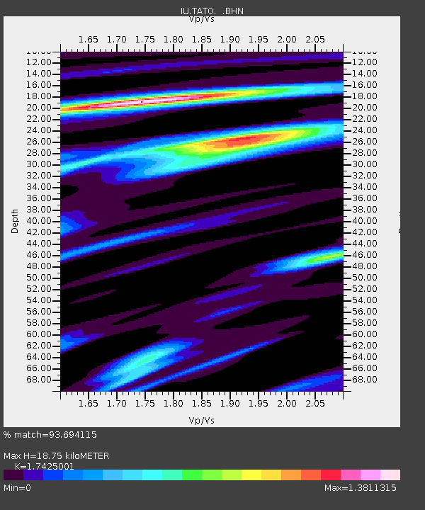
| Estimated Moho Depth: |
18.75 km |
| Estimated Crust Vp/Vs: |
1.74 |
| Assumed Crust Vp: |
6.289 km/s |
| Estimated Crust Vs: |
3.609 km/s |
| Estimated Crust Poisson's Ratio: |
0.25 |
|
| Radial Match: |
93.694115 % |
| Radial Bump: |
384 |
| Transverse Match: |
84.55494 % |
| Transverse Bump: |
400 |
| SOD ConfigId: |
6273 |
| Insert Time: |
2010-03-04 20:58:47.924 +0000 |
| GWidth: |
2.5 |
| Max Bumps: |
400 |
| Tol: |
0.001 |
|

Signal To Noise
| Channel | StoN | STA | LTA |
| IU:TATO: :BHN:19950407T22:18:04.166016Z | 2.2268233 | 5.254257E-7 | 2.3595305E-7 |
| IU:TATO: :BHE:19950407T22:18:04.166016Z | 1.999142 | 6.120801E-7 | 3.061714E-7 |
| IU:TATO: :BHZ:19950407T22:18:04.166016Z | 10.388044 | 2.7348856E-6 | 2.6327243E-7 |
| Arrivals |
| Ps | 2.3 SECOND |
| PpPs | 7.9 SECOND |
| PsPs/PpSs | 10 SECOND |


