You are here: Home > Network List > UW - Pacific Northwest Regional Seismic Network Stations List
> Station UMAT Pilot Rock, OR, USA > Earthquake Result Viewer
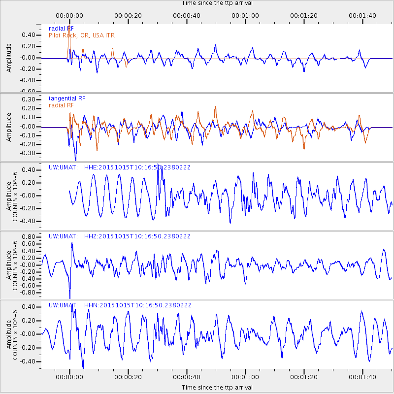
UMAT Pilot Rock, OR, USA - Earthquake Result Viewer
*The percent match for this event was below the threshold and hence no stack was calculated.
| Earthquake location: |
Ecuador |
| Earthquake latitude/longitude: |
-2.5/-78.8 |
| Earthquake time(UTC): |
2015/10/15 (288) 10:07:28 GMT |
| Earthquake Depth: |
97 km |
| Earthquake Magnitude: |
5.4 mww |
| Earthquake Catalog/Contributor: |
NEIC PDE/us |
|
| Network: |
UW Pacific Northwest Regional Seismic Network |
| Station: |
UMAT Pilot Rock, OR, USA |
| Lat/Lon: |
45.29 N/118.96 W |
| Elevation: |
1318 m |
|
| Distance: |
59.5 deg |
| Az: |
328.067 deg |
| Baz: |
131.532 deg |
| Ray Param: |
$rayparam |
*The percent match for this event was below the threshold and hence was not used in the summary stack. |
|
| Radial Match: |
50.844078 % |
| Radial Bump: |
400 |
| Transverse Match: |
53.767387 % |
| Transverse Bump: |
399 |
| SOD ConfigId: |
7422571 |
| Insert Time: |
2019-04-21 02:58:32.387 +0000 |
| GWidth: |
2.5 |
| Max Bumps: |
400 |
| Tol: |
0.001 |
|
Signal To Noise
| Channel | StoN | STA | LTA |
| UW:UMAT: :HHZ:20151015T10:16:50.238022Z | 2.0826566 | 3.3390387E-7 | 1.6032592E-7 |
| UW:UMAT: :HHN:20151015T10:16:50.238022Z | 2.9950113 | 2.8511184E-7 | 9.519558E-8 |
| UW:UMAT: :HHE:20151015T10:16:50.238022Z | 1.232335 | 2.5707615E-7 | 2.0860898E-7 |
| Arrivals |
| Ps | |
| PpPs | |
| PsPs/PpSs | |


