You are here: Home > Network List > IU - Global Seismograph Network (GSN - IRIS/USGS) Stations List
> Station TATO Taipei, Taiwan > Earthquake Result Viewer
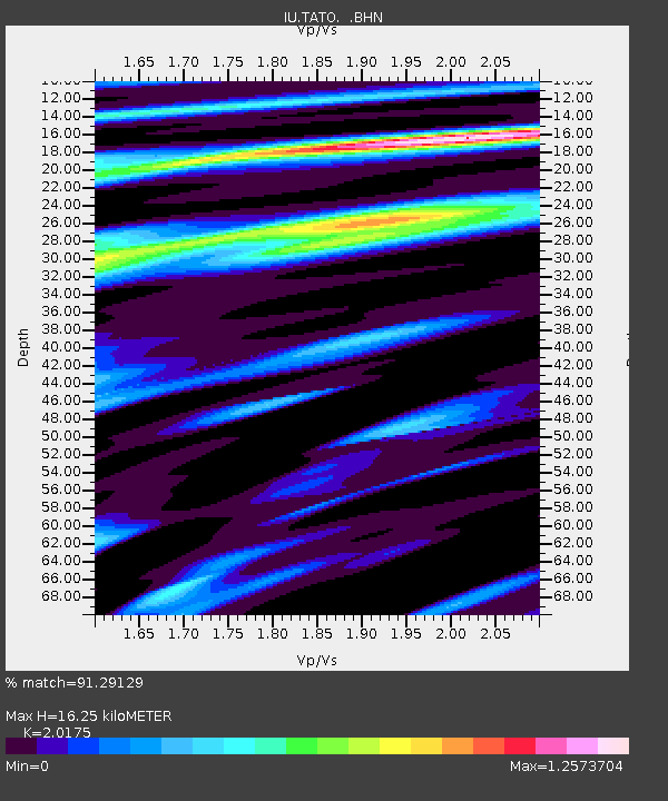
TATO Taipei, Taiwan - Earthquake Result Viewer
| Earthquake location: |
Fiji Islands Region |
| Earthquake latitude/longitude: |
-20.7/-178.3 |
| Earthquake time(UTC): |
1996/08/05 (218) 22:38:22 GMT |
| Earthquake Depth: |
550 km |
| Earthquake Magnitude: |
6.4 MB, 7.4 UNKNOWN, 7.3 MW |
| Earthquake Catalog/Contributor: |
WHDF/NEIC |
|
| Network: |
IU Global Seismograph Network (GSN - IRIS/USGS) |
| Station: |
TATO Taipei, Taiwan |
| Lat/Lon: |
24.98 N/121.49 E |
| Elevation: |
53 m |
|
| Distance: |
74.1 deg |
| Az: |
305.005 deg |
| Baz: |
122.326 deg |
| Ray Param: |
0.050815526 |
| Estimated Moho Depth: |
16.25 km |
| Estimated Crust Vp/Vs: |
2.02 |
| Assumed Crust Vp: |
6.289 km/s |
| Estimated Crust Vs: |
3.117 km/s |
| Estimated Crust Poisson's Ratio: |
0.34 |
|
| Radial Match: |
91.29129 % |
| Radial Bump: |
400 |
| Transverse Match: |
90.81361 % |
| Transverse Bump: |
400 |
| SOD ConfigId: |
6273 |
| Insert Time: |
2010-03-04 20:59:10.490 +0000 |
| GWidth: |
2.5 |
| Max Bumps: |
400 |
| Tol: |
0.001 |
|

Signal To Noise
| Channel | StoN | STA | LTA |
| IU:TATO: :BHN:19960805T22:48:30.978027Z | 4.31996 | 2.2327097E-6 | 5.168357E-7 |
| IU:TATO: :BHE:19960805T22:48:30.976013Z | 4.9956875 | 2.3931373E-6 | 4.7904064E-7 |
| IU:TATO: :BHZ:19960805T22:48:30.978027Z | 23.550812 | 1.3983098E-5 | 5.937417E-7 |
| Arrivals |
| Ps | 2.7 SECOND |
| PpPs | 7.6 SECOND |
| PsPs/PpSs | 10 SECOND |


